Q. Tell us about the Earthquake Working Group, which is run by the GSI.
Types of faults
The Earthquake Working Group consists of research institutes and universities that are studying earthquakes. Its purpose is to use satellite data to reveal how earthquakes and crustal deformation occur. When a disaster occurs, we compile the Working Group’s information requests and send them to JAXA, which then takes satellite images accordingly.
Last year, when the Great East Japan Earthquake struck, JAXA used DAICHI to make emergency observations. We analyzed the data, and released our analysis. This research is helping us understand the mechanisms that cause earthquakes.
Q. What are the mechanisms that cause earthquakes?
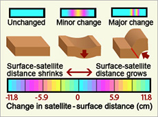
Earthquakes happen when tectonic plates rub against each other along a fault. There are two main types: dip-slip faults and strike-slip faults. In a dip-slip fault, the plate that’s moving slides up and down. This type of fault is categorized as either normal or reverse. In a normal fault, the moving plate shifts downward, whereas in a reverse fault it slides up the other way.
Along a strike-skip fault, the bedrock moves horizontally. Normally we cannot recognize such a fault by looking at it directly from the surface because the movement happens underground. However, when the fault moves, the Earth’s surface moves as well – we call that crustal movement. InSAR gives us a detailed picture of crustal deformation, so we can work backwards to speculate how the fault is moving below.
Q. What sort of cooperative framework has the GSI built with JAXA?
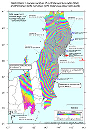
SAR interferogram showing the movement of the crust caused by the Great East Japan Earthquake. Red arrows show that the largest movement occurred on the Oshika Peninsula. (courtesy: JAXA/GSI)
![]()
The GSI has collaborated with JAXA on many joint research projects. For example, the first Japanese satellite to use SAR was FUYO-1, the Japanese Earth Resources Satellite, which was launched in 1992. We’ve since moved on to using InSAR analysis in our research, and have developed analysis software based on data from FUYO-1.
Building on Fuyou-1’s achievements, we used DAICHI, which was launched in 2006, to perform InSAR analysis on a regular basis. I think the GSI worked with DAICHI more than any other organization, particularly using InSAR.
Q. Which part of the Earth’s crust moved the most in the Great East Japan Earthquake last year?
We recorded a magnitude of 9.0 for the earthquake on March 11, 2011, making it the largest on record in Japan. We witnessed crustal deformation over a broad area stretching from the Tohoku region to the Kanto region (which includes Tokyo). The largest movement was seen at the tip of the Oshika Peninsula in northeastern Miyagi Prefecture. DAICHI’s observations showed us a crustal movement of about 4 meters away from the satellite’s position. This indicates that the Earth’s surface moved 4 meters or more eastward while sliding downward. This is the largest crustal movement in Japan that we have ever seen. That tells us just how enormous the earthquake was.
Q. What are the advantages of satellite observations?
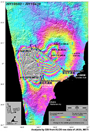
SAR interferogram showing the effects of the earthquake in Hamadori, a coastal area in Fukushima prefecture. It shows the crust’s movement for 50 km in all directions. The three disconnected lines denote the location of the fault as it appeared on the surface. (courtesy: JAXA/GSI)
![]()
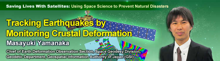
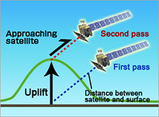
With satellite observations, we can see crustal deformation across a wide expanse of the Earth’s surface. Unlike the GPS stations in the GSI’s GEONET, which are placed about 20 kilometers apart and record data at certain points, a satellite can monitor a far wider area. I think the greatest feature of SAR-equipped satellites is that they can see a broad area all at once and perceive small movements over its entirety.
For example, on April 11, 2011, a month after the Great East Japan Earthquake, there was a magnitude-7 earthquake in Japan. Its epicenter was in Hamadori, a coastal area in Fukushima Prefecture. Looking at the InSAR imagery, you can see crustal deformation in every direction within a radius of about 50 km. The imagery also shows the exact position of the fault that the earthquake pushed to the surface. I think the InSAR technique, which can provide detailed information about a wide area, is an effective method of studying the mechanisms of such inland quakes.
Another advantage of SAR is that since it’s a type of radar, it can make observations day and night, regardless of the weather. DAICHI was also equipped with PRISM (Panchromatic Remote-sensing Instrument for Stereo Mapping), a kind of optical sensor. Such sensors work only during the day, and in fact only on bright days. So most of the PALSAR observations were made at night. Not even darkness and clouds can interfere with radar.
Q. What problems have come up so far in the use of satellites?
In DAICHI’s case, the satellite would normally pass over the same spot every 46 days, so if our luck was bad and it had just flown over, then we wouldn’t be able to get any data until the next cycle. When the earthquake struck last year, we were able to make an emergency observation of the disaster area, but we still couldn’t make a SAR observation until four days later, on March 15.
Also, we weren’t able to get an observation that covered the entire area where we thought the earthquake had caused crustal deformation, because in high-resolution mode, DAICHI’s PALSAR could only observe a swath about 70 km wide. That’s why it took about a month to complete the observations, which we did by taking separate images of each segment.
When there’s a disaster, speed is of the essence, so I’d like to be able to make observations as soon after the event as possible. In addition, I think we have to try to analyze the data more quickly, and release our analysis sooner. With DAICHI, SAR observations were made at night, we got the data the next morning and analyzed it right away, and if we got the work done quickly enough we released it that day, or at the latest the following day. When there’s a disaster, ideally I’d like to release InSAR analytical data within 24 hours of the damage.
Q. What do you think of the future potential of using satellites to reduce damage from disasters?
Currently, we can’t release InSAR data on crustal movement immediately after an earthquake because the observations take time, among other reasons. However, if we can promptly figure out the mechanisms that caused an earthquake, there is great potential for being able to predict what areas will sustain heavy damage. For example, if we know the location of the fault that caused the earthquake, then we can guess that the damage will spread along that fault. In the future, we may be able to use InSAR data to respond to an earthquake as soon as it happens. This is another reason why I think more and more speed will be demanded of us.
Q. What expectations or hopes do you have regarding JAXA?
DAICHI’s successor, ALOS-2, will be equipped with a synthetic aperture radar, and is scheduled for launch in 2013. I’ve heard that this satellite, which is still in development, will be able to observe the same location every 14 days, and that the goal is for ALOS-2 to make observations within 24 hours of a disaster. It will also have an enhanced wide-area-observation mode, so I have very high hopes for the future.
However, I think that the down time between DAICHI’s shutdown in May of last year and the launch of ALOS-2 is a major practical disadvantage. I believe that in order to commercialize the use of satellite data, we need to maintain continuous SAR satellite observation, starting with ALOS-2.
And although the GSI is collaborating with JAXA, it is physically impossible to make any observations if we don’t have a satellite over Japan taking images. Also, when a disaster occurs, we can’t speed up emergency observations if we have only one satellite, so I believe it is vital to operate multiple satellites simultaneously to further improve response time.
Chief of Earth Deformation Observation Section, Space Geodesy Division, Geodetic Department, Geospatial Information Authority of Japan
Mr. Yamanaka joined the GSI in 2002. He has worked on control point surveying, coordinating disaster response as well as managing data from GEONET (a continuous observation system utilizing GPS technology). He worked on volcano monitoring with the Japan Meteorological Agency in 2009, and has served in his current post since 2011.
Tracking Earthquakes by Monitoring Crustal Deformation
Using Satellites to Study Volcanic Activity
Using Satellites to Help Local Communities
A New Satellite to Battle Large-Scale Natural Disasters