The information on this page was published in the past, thus it may be different from the current status.
To check the date of issuance, please refer to the following URL for the list of interviews, or for the list of special articles.


MICHIBIKI Enables New Positioning Services Building a Better Satellite-Based Positioning System Satoshi Kogure Quasi-Zenith Satellite System Mission Manager, JAXA

MICHIBIKI has Accomplished its Initial Development Goal

Better Positioning in Urban Canyons

Implementing Interoperability Through International Cooperation

MICHIBIKI Expands the Possibilities of Satellite Positioning

MICHIBIKI has Accomplished its Initial Development Goal

Q. Please tell us about the current state of MICHIBIKI, the first Quasi-Zenith Satellite.

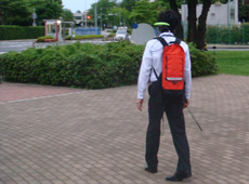
Demonstration of how a handheld navigation system employing LEX signals would be used.

MICHIBIKI was launched in September 2010, and continues to perform well. For the past two years, it has been used in technical testing of the Quasi-Zenith Satellite System (QZSS), which complements GPS operated by the U.S. and facilitates GPS based Positioning, Navigation and Timing applications even in challenging condition for satellite navigation. The initial development goal was to use MICHIBIKI to demonstrate the effectiveness of the advanced positional technology of QZSS. Multiple ministries, agencies and research institutes are involved in the MICHIBIKI project; JAXA’s task is to research and develop technology to complement GPS, and to provide the fundamental technologies for next-generation satellite positioning.

The LEX (L-band experiment) signal we are planning to use to establish next-generation positioning technology is an experimental signal unique to MICHIBIKI. At JAXA, we are using LEX signals to develop positioning technology called Precise Point Positioning (PPP). To put it simply, this is a way to create precise centimeter-scale positioning that does not use relative distances from ground-based reference points as the conventional way uses, but directly measures using a carrier phase between the satellite and a user by employing precise satellite orbit and clock information sent with MICHIBIKI’s LEX signals. Because this PPP technology does not require base stations, we expect that it may be able to perform positioning with accuracy of several centimeters even on the oceans, where there are no base stations.

Better Positioning in Urban Canyons

Q. What kind of results have your tests produced?

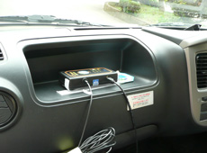
Test vehicle (bottom) equipped with a MICHIBIKI receiver (top).

JAXA lent MICHIBIKI receivers to various universities, research institutes and private companies, and conducted data acquisition tests. We wanted to verify Quasi-Zenith Satellite effectiveness in diverse environments: under the open sky, in forested areas, or in "urban canyons" - locations surrounded by tall buildings. More specifically, we collected data with the help of taxi companies, truck transport operators and delivery services. Our tests confirmed that combining GPS with MICHIBIKI made better positioning possible, even among skyscrapers, where it is difficult to get a position using GPS alone. In Tokyo’s Shinjuku district, which is packed with tall buildings, we were able to get a position 2.5 times more frequently along driving route than using GPS alone. This confirmed that the MICHIBIKI satellite - which is positioned near the sky’s zenith over Japan - can provide remarkable improvements in cities and other challenging environments for satellite positioning with poor reception.

Q. What issues do you have to deal with in the future?

Take, for example, automobile navigation systems. Currently, in urban areas filled with tall buildings, positioning is difficult - often you can’t get a precise GPS positioning result. So this is where we need to improve positioning accuracy most of all. In the future, we’d like positioning technology to be able to recognize what side of the road you’re on or which lane you’re in. To develop this capability, we need to use new signals, and precise positioning that uses multiple frequencies and carrier phase tracking, and we need to develop a carrier-phase-tracking method using the LEX signal.

But I think that ultimately we will combine MICHIBIKI with various other systems not only GPS but also other GNSS systems - just like today’s automobile navigation systems, which don’t just rely on GPS, but also use accelerometers and other sensors to improve accuracy. In fact, recent smartphones don’t just use GPS; they also have built-in receivers for Russian GLONASS satellites, to allow greater use of positioning and provide more accurate location information, even in places with poor reception.

We think that the more advanced our satellite positioning applications with using multiple GNSS constellations become, the more people will expect these services to work properly anytime, anywhere. We believe that we also need advances in improved reliability, better tolerance of interference, smoother transitions from indoor to outdoor positioning connections, etc.

Implementing Interoperability Through International Cooperation

Q. What are the global trends for satellite positioning systems?

In addition to the United States’ GPS, there are now several new positioning systems: Europe’s Galileo, Russia’s GLONASS and China’s Compass. Positioning systems were originally developed as military systems, but their applications have expanded more and more, because they now transmit signals for civilians. Because the number of frequencies and signals available for civilian use will increase in the future, it will become possible to provide highly accurate and reliable satellite positioning services. The range of possibilities for these services is enormous, and the market is global. Every country is seriously thinking about entering this market. This means that all the service providers will try to reduce discrepancies between their satellite systems and make them more user-friendly around the world. We call this "increasing interoperability."

The United Nations has a committee on the Global Navigation Satellite System (GNSS) called the International Committee on GNSS (ICG). The committee is working to rapidly increase the interoperability of the various satellite positioning systems. The purpose of the ICG is to create an environment in which we can use multiple systems, demonstrate new ways for all of us to use positioning satellites, and maximize the benefits of the GNSS. For example, they are holding discussions on using the same frequency band to send position signals, as well as making receivers capable of processing multiple satellite signals. Additionally, there are deliberations about standardizing position signals worldwide, and one day building consolidated one positioning system as an ultimate and an ideal goal. I think the integration of positioning systems is really interesting discussion.

Q. What are your thoughts on international cooperation using MICHIBIKI?

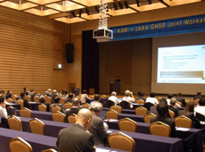
GNSS workshop held in South Korea in November 2011.

MICHIBIKI’s signals reach only Asia and Oceania, but Europe, Russia, China and India’s satellite systems also cover this area. This means that we have an environment where we’ll be able to use multiple systems sooner than any other region.

So Japan has proposed the Multi-GNSS Demonstration Campaign to the ICG, the idea being that it may be good to conduct the world’s first demonstration testing on interoperability among multiple GNSS constellations in Asia and Oceania, then provide the results as feedback for ICG deliberations. In 2010, with the backing of the ICG, an organization called Multi-GNSS Asia (MGA), which is working on making interoperability practical, was established based on Japanese initiative. As the first step, testing with MICHIBIKI receivers is just now beginning in Thailand, Malaysia, China, Australia and other countries in Asia and Oceania. MGA thinks that in the multi-GNSS era, MICHIBIKI’s augmentation capability for all GNSS will come to play a vital role, and the organization is now planning to conduct tests using not only GPS, but also Galileo, GLONASS and the like, as well as PPP using the aforementioned LEX signal.

In addition, MGA is holding workshops with the purpose of exchanging information and spreading the use of multiple satellite positioning systems in Asia and Oceania. Workshops have so far been held in Thailand and elsewhere, and the fourth GNSS Workshop is scheduled for December 2012 in Malaysia. Through these workshops, we hope to contribute, among other things, to educating professionals in developing countries and elsewhere.

MICHIBIKI Expands the Possibilities of Satellite Positioning

Q. What are some of the applications you expect to see for Quasi-Zenith Satellites?

We can think of many fields, such as disaster prevention and precise agriculture, but, for example, there are also rail and meteorological applications. For rail transport, we are conducting joint research with the Railway Technical Research Institute on whether satellite positioning can be used to operate and control trains. Presently, train operation uses a method called a signaling block system to prevent rear-end collisions and crashes. When a train’s wheels roll onto a certain segment of track, it creates a flow of electricity. This tells the operations center precisely where the train is. Workers walk along the tracks at night, after the trains stop running, to inspect the equipment and make sure it’s working properly, but this places a heavy burden on railway companies, especially in outlying areas with small populations. Thus, it is conceivable that we could install a position signal receiver to manage a train’s position. Combining MICHIBIKI with GPS in mountainous areas where you cannot get location information with GPS alone could make positioning possible here as well. In addition to contribution to reducing maintenance costs, I think this would also help streamline operations and assist drivers.

Furthermore, Dr. Toshitaka Tsuda of the Research Institute for Sustainable Humanosphere is working on predicting unexpected brief localized downpours. He is doing this by using MICHIBIKI receivers to investigate the amount of water vapor in the atmosphere. Until now he had been using GPS satellites to estimate the amount of water vapor over a broad area, at an angle of elevation of 10 degrees or greater. But because MICHIBIKI is positioned right overtop areas of Japan for hours at a time, he can get higher-resolution readings of the distribution of water vapor by pinpointing the vapor from directly above. Unexpected downpours are a meteorological phenomenon that occurs over a narrow area, so research is being conducted to find out whether MICHIBIKI’s observational data can help prevent disasters through weather forecasting and timely warnings.

We hope we can expand the range of applications for the Quasi-Zenith Satellite System to encourage more people to use it before we put it to full-scale practical use.

Satoshi Kogure
Quasi-Zenith Satellite System Mission Manager, JAXA Space Applications Mission Directorate, Satellite Applications and Promotion Center

Mr. Kogure graduated from Nagoya University in 1993 with a Master’s degree in Aerospace Aeronautical and Astronautical Engineering. He joined the National Space Development Agency of Japan (NASDA, now the Japan Aerospace Exploration Agency) that same year, and was assigned to the Tracking and Control Center, where he operated satellites. After studying at the University of Colorado, Mr. Kogure returned to Japan in 2001 and worked at the Mission Planning Department on setting up the Quasi-Zenith Satellite System. He has worked with the Quasi-Zenith Satellite System project team on positioning systems development, coordination with other satellite positioning systems such as the United States’ GPS and Europe’s Galileo, and on user interfaces. Since April 2012, Mr. Kogure has been in charge of promoting applications and technical demonstration testing of Quasi-Zenith Satellite-1 MICHIBIKI at the Satellite Applications and Promotion Center.

Return to top