Reducing cancellations caused by poor visibility
— What exactly is trajectory control technology?
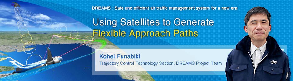
 Curved approach
 Straight-in approach with ILS
The DREAMS project has developed a technology that allows aircraft to approach the runway on a curved path when landing. This curved path still includes a straight path, so let's discuss that first. During times of poor visibility ⋅ due to fog, rain, or other bad weather ⋅ today's aircraft can still land safely into airports equipped with Instrument Landing Systems (ILS). The ILS system on the ground emits signals that the aircraft uses to create a virtual path, which it then follows as it lands. This is known as the instrument approach. Using ILS, however, requires a straight path to the runway of at least 5 km, which precludes ILS from being used at airports surrounded by mountains or densely populated areas. At more than half the airports in Japan, aircraft are limited to an approach from only one direction due to the local terrain. At the same time, even at airports that have ILS, wind may cause pilots to approach from an orientation with which ILS cannot be used. In this case, aircraft cannot land in poor visibility. Low visibility due to bad weather accounts for 25 percent of all cancellations.
To help solve this problem, the DREAMS project's Trajectory Control Technology Section has developed precision curved approach by making use of the Ground Based Augmentation System (GBAS). Instead of using ground-based signals like ILS, GBAS gets information from GPS satellites to reliably and accurately determine the position of the aircraft. We have developed a technology that generates curved approach paths, reduces the straight path to 2 km, and enables aircraft to follow this path in autopilot mode. The ability to generate approach paths flexibly, in accordance with weather conditions and aircraft position, reduces cancellations due to bad weather, and thus improves airport service ratios.
Using data from multiple sources to generate flexible paths
— How does this system work?
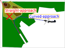
 Approach using GBAS (straight line) and FMS (curved line)
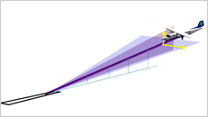
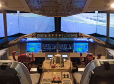 Flight simulator
We've devised two methods. The first uses the aircraft's on-board Flight Management System (FMS) to generate the curved-path portion of the approach, and then uses ground-based GBAS to generate the straight-path portion. However, paths generated by FMS are specific to the air, so there are times when these paths do not match up with the GBAS path.
Here's what I mean when I say that FMS paths are specific to the air. The speed of aircraft is represented not by the distance covered on the ground, but by how fast the aircraft is traveling in relation to the surrounding air. An airspeed of 100 knots represents the speed in relation to the surrounding air, not the speed when looking at the aircraft from the ground. So for example, if an aircraft is flying at 100 knots with a tailwind of 20 knots, then its airspeed is still 100, but the speed as seen from the ground is 120 knots. Also, the altitude of the aircraft is not a representation of the distance from the ground. Altimeters in aircraft do not actually measure the altitude. Instead they measure air pressure, which is to say, a representation of the altitude as measured by air pressure. For example, at an ambient temperature of 15℃, an altitude of 500 m above sea level will be measured as 500 m, but a change in temperature to -25℃ will cause a change in pressure and a corresponding change in the altimeter reading to 590 m.
Conversely, GBAS calculates values using the Earth for constants. This sometimes causes deviations at the point where the FMS-based curved path and the GBAS-based straight path cross. When the ambient temperature is at least 15 degrees above or below the standard atmospheric temperature, these paths will no longer match. The first method I mentioned earlier resolves this issue. Specifically, we used a flight simulator to figure out which descent angles are not easily affected by ambient temperature, by changing the descent angle of the curved path many times using many different angles. As a result, we discovered that for some aircraft models, steep descent angles are easier to match during low temperatures, and gentle descents are easier to match during high temperatures. We can align the GBAS and FMS paths over a wide range of temperatures by changing the shape of the path in accordance with the temperature. This is what enables us to generate flexible paths.
Using curved paths on autopilot
— And what about the second method?
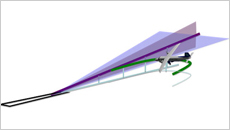
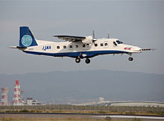 Autopilot curved approach testing
This method involves sending all path information ⋅ for both the straight path and the curved path ⋅ from the GBAS equipment on the ground to aircraft equipped with GBAS receivers. Existing autopilot systems do not support curved approaches, so we needed to create an autopilot algorithm that does. We developed a new algorithm, and tested it on the JAXA flying test bed MuPAL-α (Dornier Do2208-202). With support from the Electronic Navigation Research Institute (ENRI) and commercial airlines, we sent signals from a GBAS test station on the ground to the flying test bed, and tested whether or not the aircraft could operate on autopilot using this path information. We also tested on days when wind was strong and likely to cause significant variations in paths. We were able to fly with an accuracy at which the straight paths and curved paths were almost the same. These experiments showed us that the technology is viable.
— How soon will this be put into practical use?
Before a new operation method can be put into practical use, many different organizations and authorities must examine the technical data from different perspectives and then work together to resolve all issues and risks. The International Civil Aviation Organization (ICAO) , a United Nations specialized agency, will organize these discussions and work towards standardizing the technology. It will take a rather significant amount of time and technical review to ensure sufficient safety. DREAMS results are also reported to international standardization organizations, which leads to the development of global standards.
— What are your plans for future projects?

The Trajectory Control Technology Section under the DREAMS project is developing technology that's applicable to both current and next-generation aircraft. Specifically, technology to fly along curved approaches via autopilot requires an equipment update, so this is more of a future technology to be considered when designing new aircraft. We will continue to look for the best way to bring these technologies to the end user.
Kohei Funabiki

Leader of the Trajectory Control Technology Section
DREAMS Project Team, Aeronautical Technology Directorate, JAXA
After joining the National Aerospace Laboratory of Japan (now JAXA), Mr. Funabiki took part in research on pilot situational awareness and workload, and on human interfaces in the cockpit. He has also participated in various flight tests and simulation experiments. He specializes in human factors in aviation, and also serves as the Human Factors Section Leader for the Flight Research Center at JAXA's Aeronautical Technology Directorate.
[ April 1, 2015 ]
- Managing Growing Air Traffic with New Technology
- Helping Pilots by Predicting Wind
- Using Weather Conditions to Reduce Aircraft Noise
- Better Satellite Navigation for Airplane Landings
- Using Satellites to Generate Flexible Approach Paths
- A Network to Coordinate Rescue Aircraft