In pursuit of reliable avoidance of adverse weather conditions,
ZIPAIR MTI, and JAXA will begin collaboration on 3D ARVI.
— Aiming towards being able to confirm the latest weather information in the cockpit and choose safer flight routes—
Japan Aerospace Exploration Agency
ZIPAIR Tokyo Inc.
MTI Ltd.
ZIPAIR Tokyo Inc., MTI Ltd., and the Japan Aerospace Exploration Agency (hereinafter JAXA) have launched a collaboration on the streamlining of weather data and visualization of rain cloud information to reduce the risk of lightning strikes to aircraft.
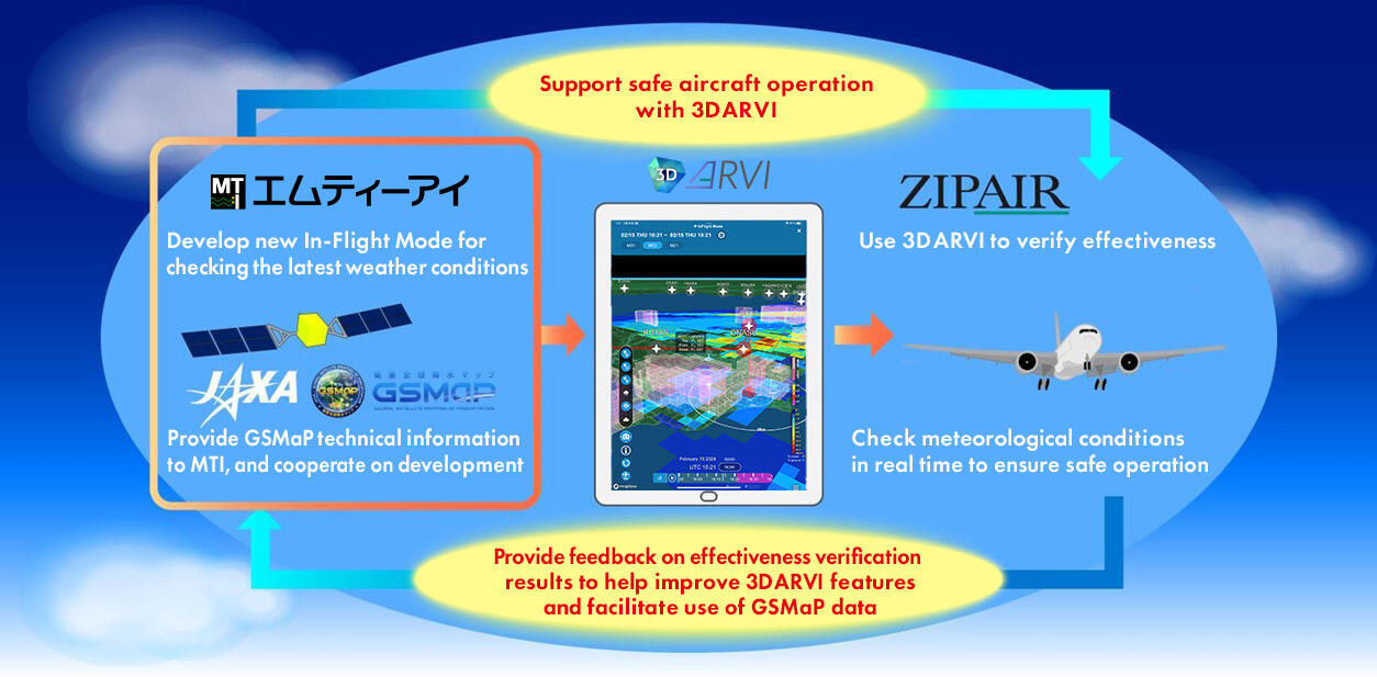
MTI's 3D ARVI system has been equipped with JAXA`s Global Satellite Mapping of Precipitation (GSMaP) data and a new In-Flight Mode has been developed. Through the implementation of this technology,pilots will have access to the latest weather information from the cockpit, allowing them to select the safest flight route to their destination.

©ZIPAIR/MTI/JAXA
◆ Formation of the Collaboration – Development of an In-Flight Mode System
Understanding weather conditions is an important element in the operation of an aircraft. Lightning strikes, in particular, are often triggered when aircraft operate near clouds where a charge buildup is occurring. Several hundred lightning incidents cause damage to aircraft in Japan each year, and measures to mitigate these risks are urgently required.(1) In order to accurately predict the location of lightning strikes, an individual will need access to real-time weather data. However, until recently, access to a network-based weather service system was not available inside a cockpit, as electromagnetic interference may cause aircraft equipment to degrade or malfunction.
In light of this situation, ZIPAIR, MTI, and JAXA are working together to resolve these issues by implementing an In-Flight Mode within the 3D ARVI system, allowing pilots to access real-time data from the aircraft. The technology will be progressively implemented on aircraft, starting in April 2024. JAXA is working to promote the usage of Earth observation data in various fields using cutting-edge space technology to resolve societal issues, such as aircraft lighting strikes. As part of this initiative, JAXA's GSMaP data has been added to the 3D ARVI system, enabling pilots to be aware of meteorological information from the cockpit. This is the first time that aircraft have been equipped with GSMaP data.
◆ Details of In-Flight Mode – 3D ARVI System
In-Flight Mode leverages 3D graphic technology, developed by MTI, to significantly streamline high-volume meteorological data for transmission within the cockpit. pilots can combine advice from air traffic controllers with the latest meteorological information displayed clearly on the cockpit tablet in three-dimensional format. In addition, JAXA's GSMaP system provides satellite access to raincloud information on a global scale during the flight.
Going forward, ZIPAIR and MTI will verify the effectiveness of this system to help reduce damage to aircraft from lightning strikes, with the intent of promoting safe and accurate flight operations. Based on the feedback obtained from ZIPAIR, JAXA aims to improve GSMaP and promote the utilization of Earth observation data in new fields.

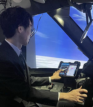
Figure 1: In-Flight Mode in use
<Aviation Weather Services ARVI and 3D ARVI>
ARVI is an aviation weather system which allows users to check meteorological information that affects aircraft operations and flight plans on a single screen.
The system allows users to check real-time weather phenomena and flight routes at a glance, helping flight dispatchers select routes with good weather conditions for safe flight plans. And, by maintaining smooth operation even when displaying multiple meteorological information sources that involve large amounts of data, ARVI improves the efficiency of operations and allows flight dispatchers and pilots to quickly check for dangerous weather phenomena along their route. MTI also provides 3D ARVI, which visualizes meteorological phenomena in 3D. It helps aircraft ensure safe operation by making it possible to grasp information quickly and intuitively.
3D ARVI's In-Flight Mode is a feature that significantly streamlines meteorological data so that users can check the latest meteorological information from within the cockpit of their aircraft during flight.
For more details about ARVI, visit: https://www.aviavi-arvi.com/enExternal Link
<Global Satellite Precipitation Map "GSMaP">
JAXA provides the Near-Real-Time Global Rainfall Map (GSMaP) by merging satellite data primarily from Global Precipitation Measurement (GPM) Core Observatory, the JAXA’s GCOM-W (Global Change Observation Mission – Water; nicknamed "Shizuku"), passive microwave radiometer data, and geostationary meteorological satellite data.
GSMaP achieves this by integrating data from multiple satellites, based on data from the Dual-frequency Precipitation Radar (DPR) developed by Japan and carried by GPM Core Observatory. Since JAXA started to operate the JAXA Global Rainfall Watch website that visualizes GSMaP data in November 2007, its data has been utilized by registered users in 150 countries working in numerous fields such as precipitation monitoring, flood forecasting, drought monitoring, and agriculture.
For more details about GSMaP, visit: https://sharaku.eorc.jaxa.jp/GSMaP/External Link


