First images from Advanced Land Observing Satellite-4 “DAICHI-4” (ALOS-4) / Phased Array type L-band Synthetic Aperture Radar-3 (PALSAR-3)
- Extended swath width to 200 km with world's highest resolution (3 m) -
July 31, 2024 (JST)
Japan Aerospace Exploration Agency
Japan Aerospace Exploration Agency (JAXA) is currently conducting the initial functional verification operations for the Advanced Land Observing Satellite-4 “DAICHI-4” (ALOS-4), which was launched on July 1, 2024. We have obtained the first observation images using the L-band Synthetic Aperture Radar (PALSAR-3) (*1) onboard the satellite during the period of July 15 to 17, 2024 (Japan Standard Time), and we are now making them publicly available.
“DAICHI-4” is a radar satellite with up to four times wider observation swath width while maintaining the high spatial resolution of its predecessor “DAICHI-2”, by applying the Digital Beam Forming technology (*2) that is the world’s first demonstration as the spaceborne Synthetic Aperture Radar (SAR). Both “DAICHI-2” and “DAICHI-4” are expected to contribute to understanding disaster situations, environmental observations like forest distribution, ocean observations such as sea ice, and so on.
■Successfully observed over a 200 km swath width
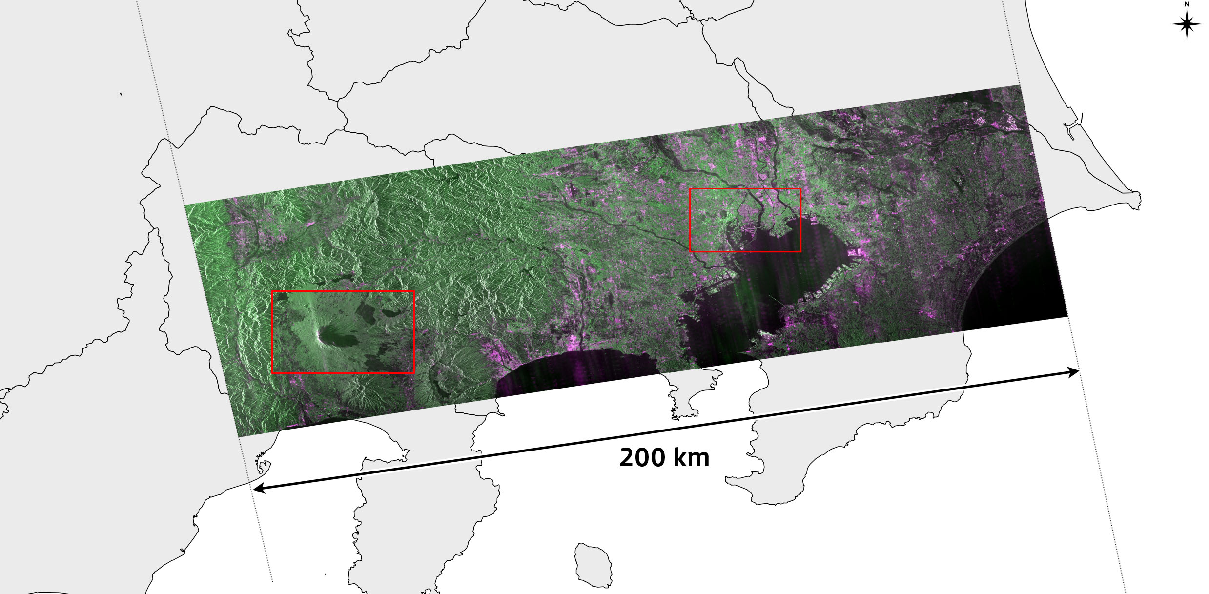
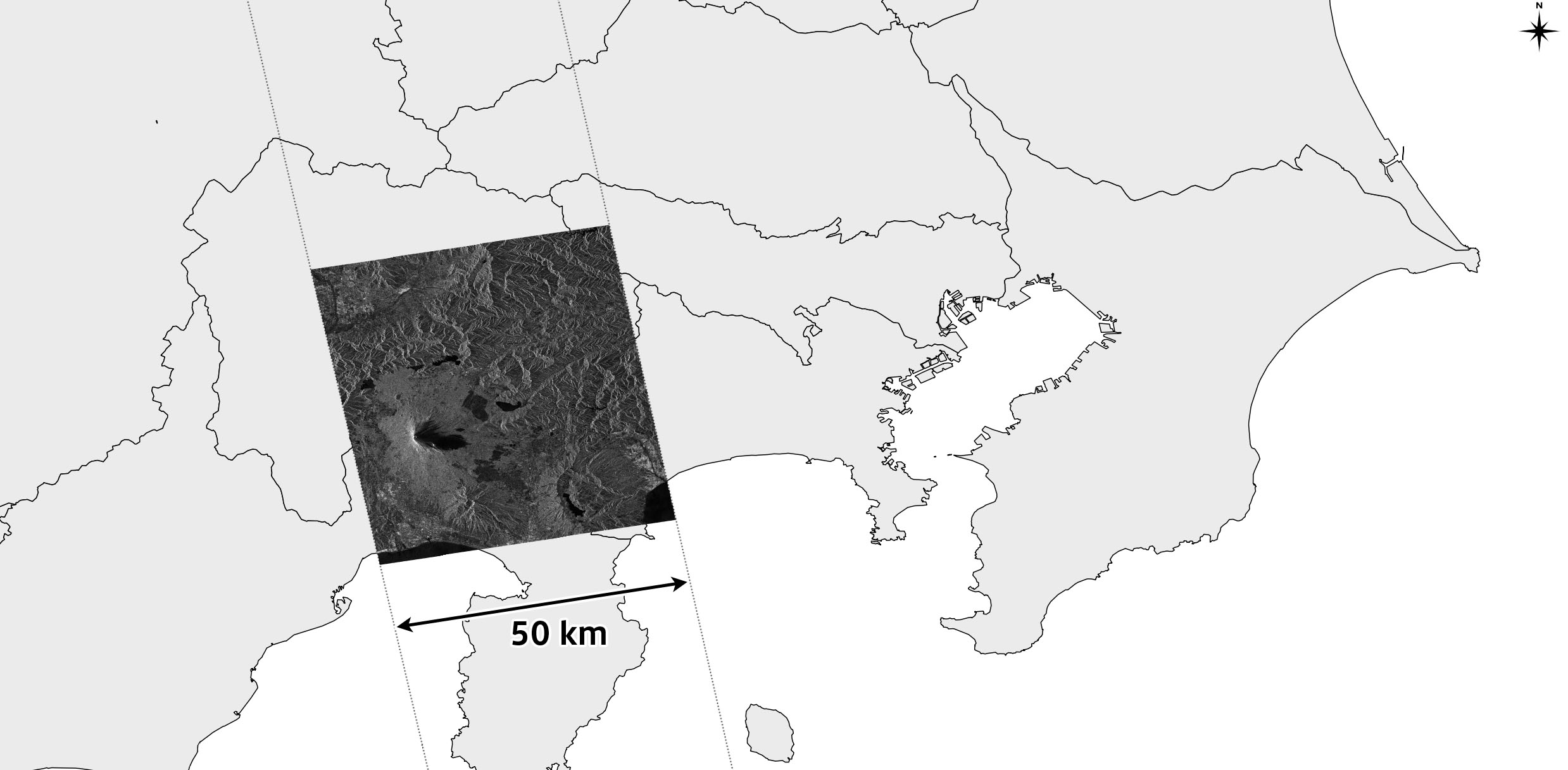
Figure 1:
(Left) Observation including the Kanto region and the vicinity of Mount Fuji by “DAICHI-4” PALSAR-3 (Resolution 3 m, observation width 200 km), Observation Date: July 15, 2024
(Right) Observation of the vicinity of Mount Fuji by “DAICHI-2” PALSAR-2 (Resolution 3 m, observation width 50 km), Observation date: November 23, 2022 (for comparison)
*Both images indicate a range of 70 km in north-south direction.
■High-Speed Data Transmission
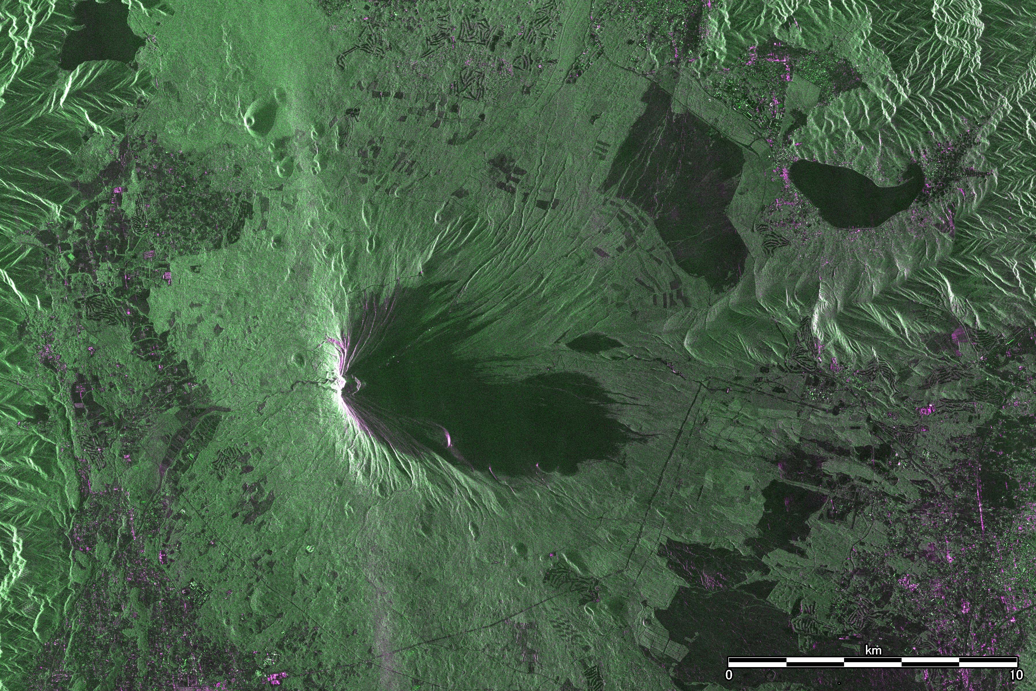
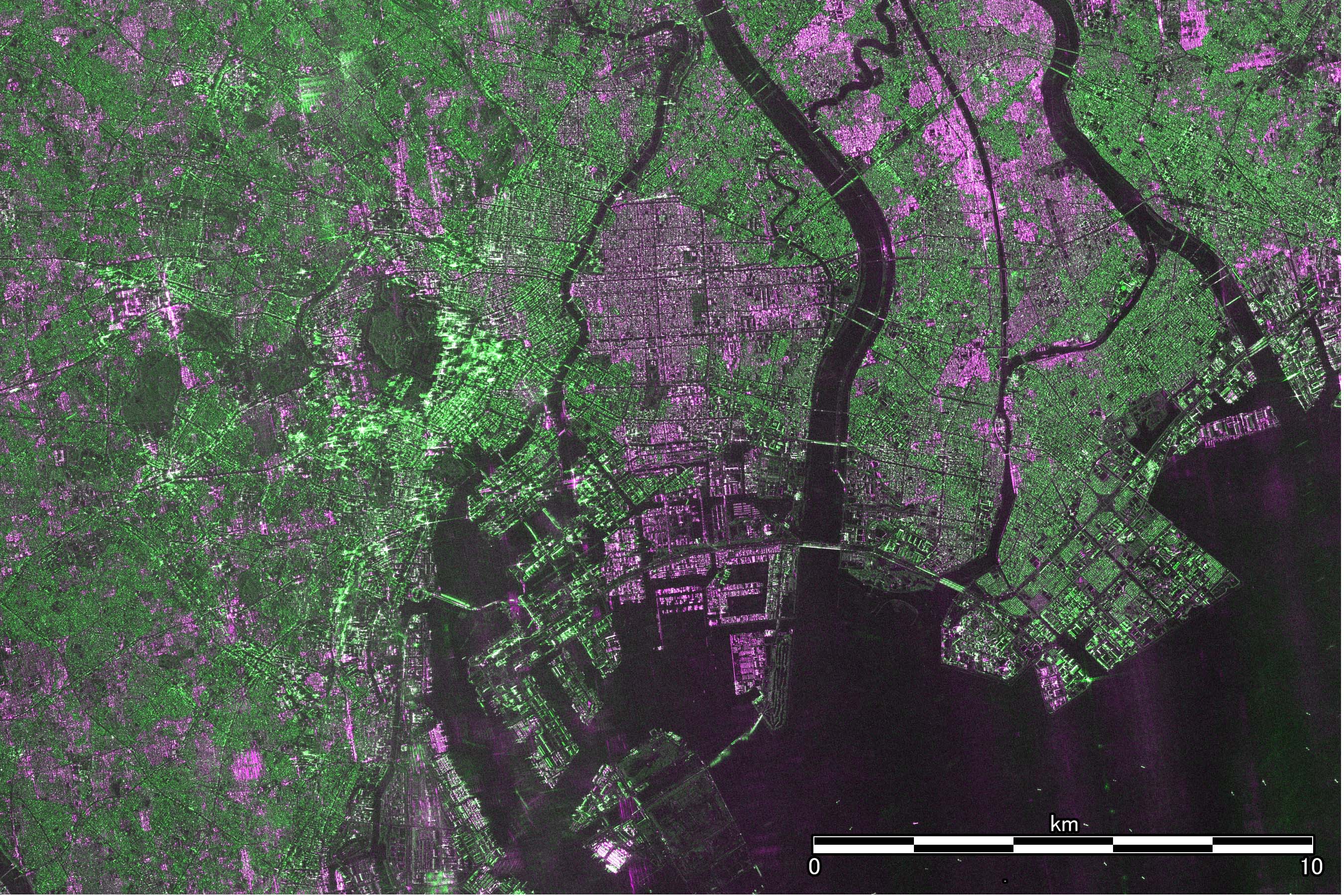
Figure 2:
Enlarged images of the vicinity of Mount Fuji and downtown Tokyo by PALSAR-3 (excerpt from the red square areas of Figure 1 (left))
“DAICHI-4” is capable of high-speed data transmission at 3.6 Gbps (1.8 Gbps x 2 systems), which is the world highest performance as an Earth observation satellite, enabling constant dual-polarization observation with HH polarization (horizontal polarization transmission and horizontal polarization reception) and HV polarization (horizontal polarization transmission and vertical polarization reception), even in high-resolution (3 m) observations which generate large amounts of data. Images of “DAICHI-4” in Figures 1 and 2 are pseudo-color images synthesized from the data of these dual-polarization observations. Green indicates vegetation and forest, bright purple and green indicate urban areas, and dark purple and black indicate bare ground or water surface. Polarization information facilitates the identification of the ground surface conditions. This is expected to be useful for understanding disaster situations and monitor deforestation.
■Upcoming Plans
The ALOS-4 project team, together with the prime contractor, Mitsubishi Electric Corporation, and various other companies and organizations involved in satellite operations, is conducting the initial functional verification operations for three months. After confirming that “DAICHI-4” and PALSAR-3 are performing nominally as expected, we will proceed on to the initial calibration and validation operations for the observational data.
*1
Phased Array type L-band Synthetic Aperture Radar (PALSAR-3)
The Phased Array type L-band Synthetic Aperture Radar-3 is a sensor onboard “DAICHI-4” which obtains information by transmitting microwave to the Earth's surface and receiving it reflected from the surface.
PALSAR: Onboard “DAICHI” (ALOS) (Launched in 2006)
PALSAR-2: Onboard “DAICHI-2” (ALOS-2) (Launched in 2014)
*2
Digital Beam Forming technology
The Digital Beam Forming is a technology that enables arbitrary generate the beam direction by rapidly processes the radio waves received by the antenna onboard via digital means and adjusting the phase and synthesizing the signal. As a result, “DAICHI-4” can form beams in up to four directions simultaneously.
Appendix
■The First Observation Images
During the initial functional verification operations from July 15 to 17, 2024 (JST, the same applies hereinafter), JAXA conducted test microwave emissions from the PALSAR-3 onboard “DAICHI-4”.
The acquired observation images are shown in Appendix Table 1.
JAXA has been gradually confirming that the various observation modes of “DAICHI-4” function nominally in the initial functional verification operations.
Noises can be seen in some of the images; however, this is because it is before the implementation of ground processing tuning according to the performance of the instrument in orbit, and we plan to optimize in the ongoing initial functional verification operations and the upcoming initial calibration and validation operations.
| Observation Date (JST) |
Observation Mode | Observed Location | Remarks | |
|---|---|---|---|---|
| (i) | July 15, 2024 11:07 |
Resolution 3 m, Observation width 100 km | Sapporo-Chitose-Tomakomai, Japan | “The First Image” |
| (ii) | July 15, 2024 23:38 |
Resolution 3 m, Observation width 200 km | Kanto Region-Vicinity of Mt. Fuji, Japan | Same as the images in the press release |
| (iii) | July 15, 2024 13:43 |
Resolution 10 m, Observation width 200 km | Rondonia State, Brazil | Comparison among PALSAR, PALSAR-2, and PALSAR-3 |
| (iv) | July 16, 2024 21:10 |
Resolution 1 m × 3 m, Observation range of 35 km square (Spotlight mode) |
Paris, France | The most detailed observation |
■Publication of Sample Data (For Browsing)
Regarding the observation images of the Kanto region taken by “DAICHI-4” introduced in this press release, we have released sample data (format: GeoTIFF, pixel spacing approximately 20 meters) on the following site, which can be viewed using GIS (Geographic Information System) software or similar tools.
Please note that the provision of the standard product is due to begin after the completion of the initial calibration and validation operations.
For more details, please check the URL below.
https://www.satnavi.jaxa.jp/ja/news/2024/07/31/9609/index.html(Japanese Only)
■“DAICHI-4” PALSAR-3 Observation (i)
Observation image of Sapporo-Chitose-Tomakomai by observation mode with 3 m resolution and 100 km width as “The First Image”
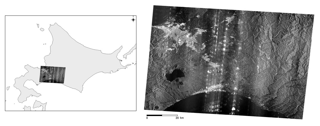
Appendix Figure 1
"The First Image" by “DAICHI-4” PALSAR-3
(Sapporo-Chitose-Tomakomai, Stripmap mode (3 m resolution), observation width 100 km, incident angle about 65 degrees, HH polarization)
PALSAR-3 performed its first observation using the Stripmap mode (3 m resolution) around 11:07 am on July 15, 2024, during the process of its initial functional verification operations, and successfully acquired the image. Appendix Figure1 shows the image of Hokkaido (Sapporo-Chitose-Tomakomai) obtained from this observation. PALSAR-3 has various observation modes with different observation widths and resolutions, and in this particular instance, images were acquired with 100 km width.
■“DAICHI-4” PALSAR-3 Observation (ii)
Observation image including the Kanto region and the vicinity of Mount Fuji using standard observation mode with 3 m resolution and 200 km width
Appendix Figure 2
Observation including the Kanto region and the vicinity of Mount Fuji by “DAICHI-4” PALSAR-3
(3 m resolution, 200 km width), Observation date: July 15, 2024
Appendix Figure 3
Observation of the vicinity of Mount Fuji by “DAICHI-2” PALSAR-2
(3 m resolution, 50 km width), Observation date: November 23, 2022 (For comparison)
Appendix Figure 4
Enlarged images of Mount Fuji and downtown Tokyo by PALSAR-3
Appendix Figure 2 is the observation image including the Kanto region and the vicinity of Mount Fuji, by PALSAR-3 Stripmap mode (3 m resolution) around 11:38 pm on July 15, 2024. It is the first image of a 200 km width area successfully observed by 3 m resolution Stripmap mode. Appendix Figure 3 is an example for comparison, showing the observation image by the Phased Array type L-band Synthetic Aperture Radar-2 (PALSAR-2) on “DAICHI-2” on November 23, 2022. Appendix Figure 4 shows enlarged images of the red square areas (Mount Fuji and downtown Tokyo) in Appendix Figure 2. PALSAR-2 and PALSAR-3 enable long contiguous observation in north-south direction; this time, only areas of approximately 70 km in the north-south direction are shown.
The observation swath width of “DAICHI-4” is significantly expanded from 50 km to 200 km, maintaining 3 m resolution (the world's highest resolution as spaceborne L-band SAR) same as those of “DAICHI-2”. This combination of high resolution and wide swath observation is expected to be used for rapid assessment of a large-scale/multipoint disaster situation. The increased opportunity for observation with expanded observation width enables regular high-frequency time-series observations (approximately 20 times a year for both day and night) of all of Japan, which is expected to advance and revitalize the use of data during normal times, such as monitoring of crustal movement on the Earth's surface and infrastructure displacement, assessing of agricultural conditions of crops, and detecting of early-stage deforestation etc.
Moreover, “DAICHI-4” is capable of high-speed data transmission at 3.6 Gbps (1.8 Gbps x 2 systems), which is the world highest performance as an Earth observation satellite, enabling constant dual-polarization observation with HH polarization (horizontal polarization transmission and horizontal polarization reception) and HV polarization (horizontal polarization transmission and vertical polarization reception), even in high-resolution (3m) observations which generate large amounts of data. Images of “DAICHI-4” in Figures 1 and 2 of the press release are pseudo-color images synthesized from the data of these dual-polarization observations. Green indicates vegetation and forest, bright purple and green indicate urban areas, and dark purple and black indicate bare ground or water surface. With enlightening information based on polarization, it becomes easier to discern the condition of the ground surface. This is expected to be useful for purposes such as understanding disaster situations and monitoring deforestation.
■“DAICHI-4” PALSAR-3 Observation (iii)
Observation images of near the state of Rondonia, Brazil, with 10 m resolution and 200 km width (importance of continuous observation)
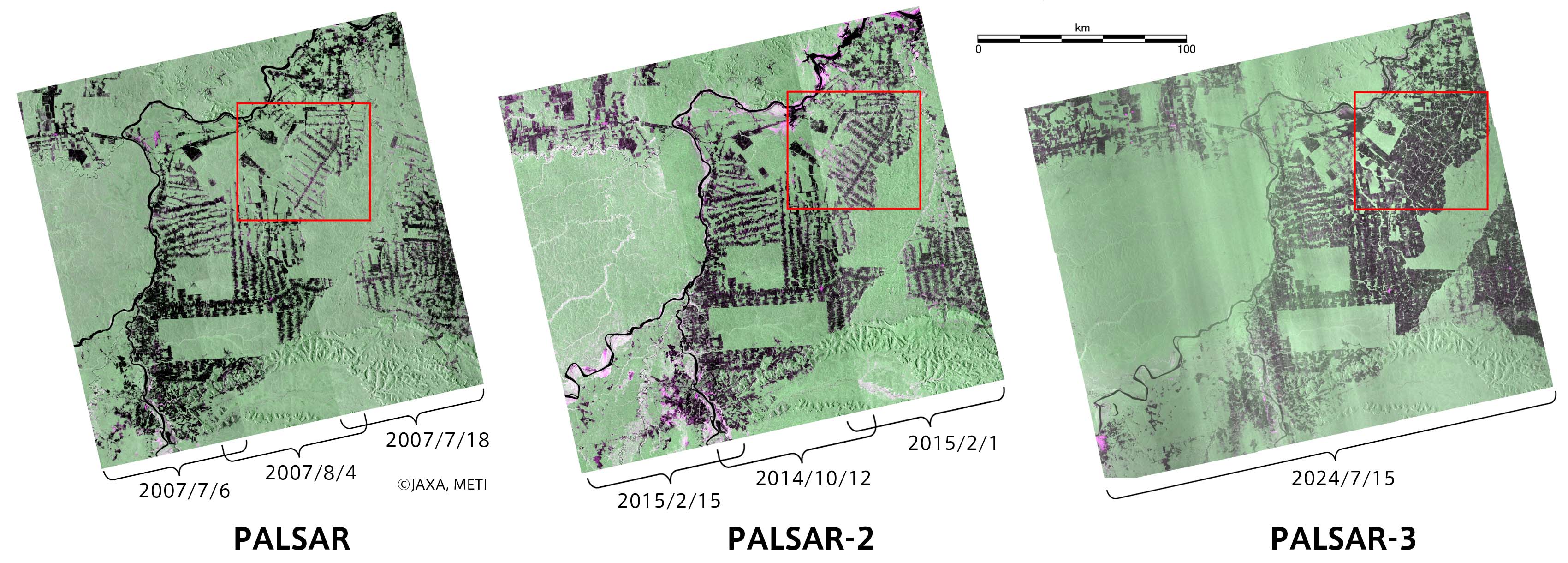
Appendix Figure 5
Comparison of observation images of the State of Rondonia, Brazil by PALSAR (2007), PALSAR-2 (2014-2015), and PALSAR-3 (2024)
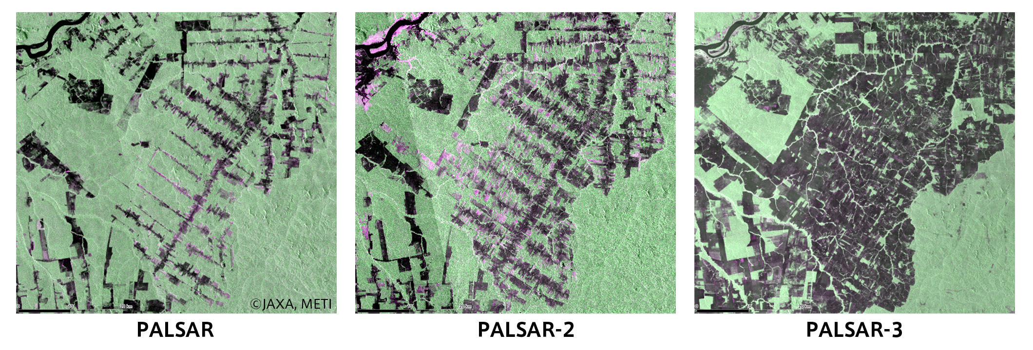
Appendix Figure 6
Enlarged images of the red square areas in Appendix Figure 5
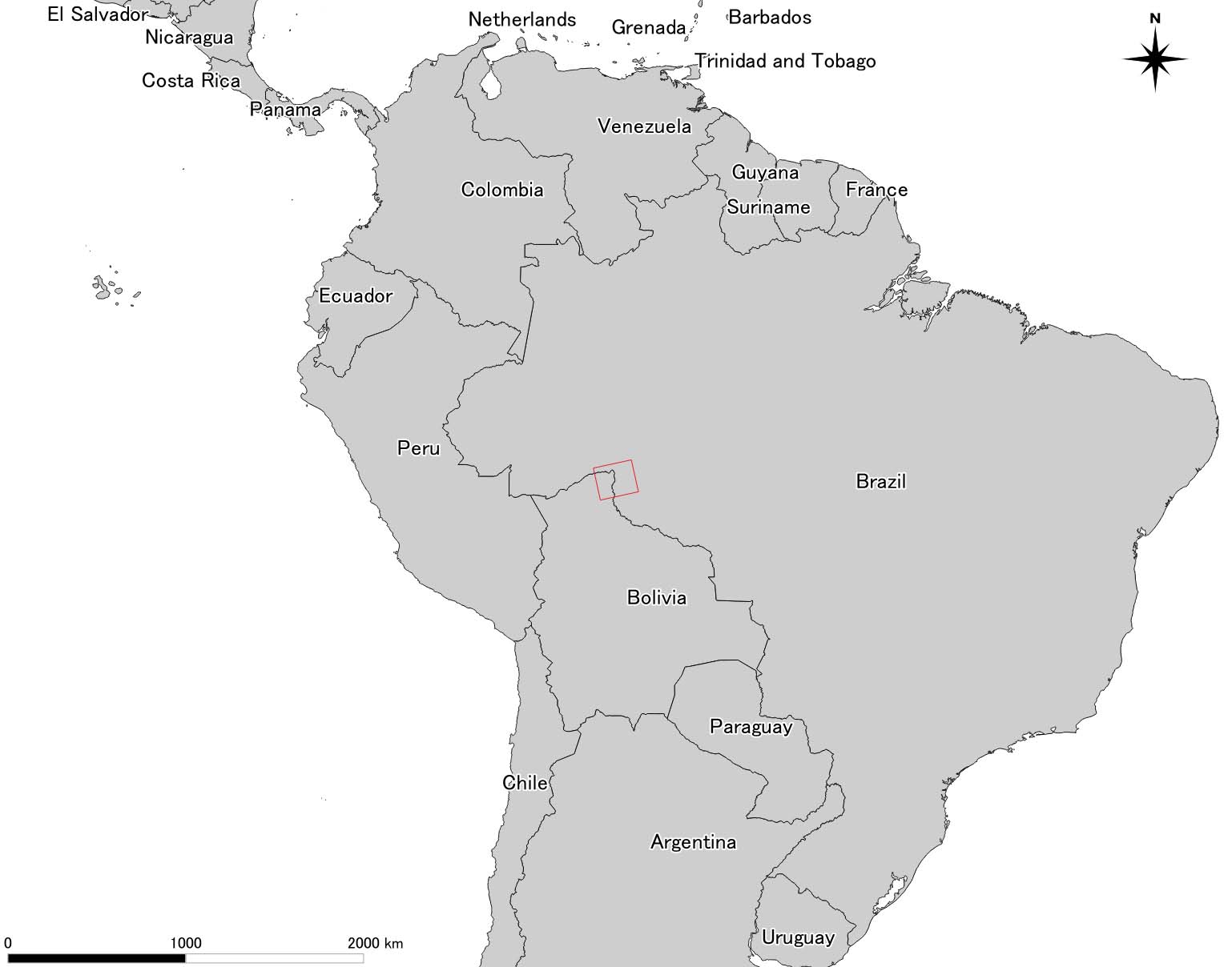
Appendix Figure 7
Observation range of Appendix Figure 5 (red square)
PALSAR, PALSAR-2, and PALSAR-3 are all synthetic aperture radars using L-band microwave, which are suitable for forest observation. The data accumulated by previous satellites and continuous forest observations by PALSAR-3 going forward, are expected to contribute to forest conservation and management, monitoring changes in forest distribution related to climate change issues, and biomass estimates amongst other things. Appendix Figure 5 shows the image of the tropical region in Brazil observed in Stripmap mode (10 m resolution) by PALSAR, PALSAR-2, and PALSAR-3 (the range shown in Appendix Figure 7). An area covered by three observations with PALSAR or PALSAR-2 can be covered by a single observation with PALSAR-3 due to its wider observation swath. Appendix Figure 6 shows enlarged images of a region where deforestation is progressing. These images are pseudo-color images synthesized from the data of dual-polarization observations, same as the images in Appendix Figure 4, showing that the green parts indicate forests, and the darker parts are presumed to be areas where the forest has been lost. By comparing the images obtained by PALSAR in 2007, PALSAR-2 in 2014-2015, and PALSAR-3 in 2024, it is noticeable that the darker areas, which indicate forest loss, have expanded over time. In this way, comparison with past observation data is needed in order to understand the changes in the global environment, emphasizing the importance of continued observation.
■“DAICHI-4” PALSAR-3 Observation (iv)
Detailed observation image of the area around Paris, France in Spotlight mode (with observation range of 35 square kilometers and resolution of 1 m × 3 m)
Appendix Figure 8
Spotlight mode image of the surrounding area of Paris, France, by PALSAR-3
(The yellow square indicates the observation range reference by PALSAR-2.)
The red square area is enlarged in Appendix Figure 9.
Appendix Figure 9
Enlarged image of the red square in Appendix Figure 8 (Paris and major venues of the Paris 2024 Olympic Games)
Appendix Figure 8 shows an observation image of the area around Paris, France, at around 9:10 pm on July 16, 2024, in Spotlight mode of PALSAR-3.
The Spotlight mode provides the highest resolution and the most detailed observations in the various modes of “DAICHI-4”, which is the resolution to 1 m in the direction of satellite movement. While PALSAR-2 on “DAICHI-2” can observe an area of about 25 km x 25 km , PALSAR-3 on “DAICHI-4” can observe an area of about 35 km x 35 km, about twice as large. In addition, PALSAR-3 brings a new capability for dual-polarization observation in the Spotlight mode as well, which is presented in pseudo-color, as in the images in Appendix Figure 4.
Similarly, Appendix Figure 9 is an enlarged image of red square area in Appendix Figure 8, the surrounding area of Paris. Major venues for the Paris 2024 Olympics Games are marked with white circles ((1) Stade de France, the main venue, (2) Porte de la Chapelle Arena, (3) Place de la Concorde, (4) Eiffel Tower Stadium, and (5) Parc des Princes).