About Experimental Geodetic Satellite "AJISAI" (EGS)
 |
To establish Japan’s geodetic origin through accurate land surveying from space.The primary short-range objective for AJISAI (EGS) was testing of NASDA's H-I'(2-stage) launch vehicle. Long-range applications included a survey aimed at rectifying Japan's domestic geodetic triangular net - determining the exact position of many isolated Japanese islands and establishing Japan's geodetic point of origin. Lauch date: August 13, 1986 |
|---|
Project Topics
indexAJISAI marked 30th anniversary on Aug. 13, 2016, and its operation still continues
|
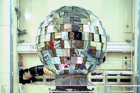
The Experimental Geodetic Satellite "AJISAI" (EGS)" was launched at 5:45 a.m. on Aug 13, 1986 (JST) from the Tanegashima Space Center and it was put into a circular orbit at an altitude of 1,500 km by the maiden H-I Launch Vehicle. AJISAI is the first Japanese geometric satellite, and its major missions are rectifying Japan's domestic geodetic triangular net -- determining the exact position of many isolated Japanese islands and establishing Japan's geodetic point of origin. AJISAI is a ball-... |
|---|
Characteristics of Experimental Geodetic Satellite "AJISAI" (EGS)
Major Characteristics
| International Designation Code | 1986-061A |
|---|---|
| Launch Date | 05:45, August 13, 1986 (JST) |
| Launch Vehicle | H-I Launch Vehicle No.1(H15F) |
| Location | Tanegashima Space Center |
| Shape | 215cm(D) sphere with solar ray and laser beam reflectors. |
| Weight | Approx. 685kg |
| Orbiter | circular |
| Altitude | Approx. 1500km |
| Inclination | Approx. 50 deg |
| Period | Approx. 116 minutes |
| Attitude Control | Spin-stabilization |