Space Technology Directorate I
Monitoring Lifeline Infrastructures on the Ground Using Satellite Data (ANATIS)
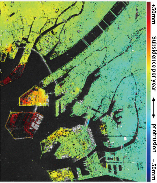
In recent years, Japan's infrastructure (lifelines such as airports, embankments, etc.) have been deteriorating from age, causing such social problems as increasing risk of accidents, rising maintenance costs, and declining number of inspection engineers. Determined to find a solution to this problem, Space Technology Directorate I developed the "Automated Nationwide Application of Timeseries InSar (ANATIS)," a tool for monitoring infrastructure displacements using satellite SAR data. ANATIS is a system that analyzes observation data received from the Advanced Land Observing Satellite-2 "DAICHI-2" and creates a visibly recognizable representation of displacements in our infrastructure. It makes it possible to check, using visual images, how much the structures on the ground or the ground surface have subsided or protruded within a set period of time. It uses observation data taken from radar that possess outstanding permeability through vegetation, so that the ground surface can be measured accurately, even when used on embankments that are covered by grass. Another feature of this system is that the analysis is performed automatically, thus making it easy to be used even by people who do not have specialized knowledge. Until now, infrastructure inspections have been performed visually, but by using ANATIS, infrastructures can be monitored efficiently, covering a broader range of areas and at a higher frequency.
Development of this system started in 2014, and a prototype was completed in 2017. Demonstration tests were conducted by construction consultants and survey companies, and in July of this year, ANATIS was registered and publicly released on the "New Technology Information System (NETIS)" operated by the Ministry of Land, Infrastructure, Transport and Tourism. Naoya Tomii, the Project Leader, looks back at their efforts saying, "We underwent repeated trial and error until the users were able to feel confident that they would be able to do business with ANATIS."
"We searched for areas that we could designate to perform the analysis, how to output the analysis, and how to make the results visible. As a result, every year since FY2017, Nippon Koei, the construction consultant with whom we partnered with, has been entrusted with the business of performing survey inspections on the river by utilizing ANATIS. And they are delivering analysis results that have a high level of accuracy."
The immediate mission is to make ANATIS more widely known.
"In order to promote the social implementation of ANATIS, the best way is to have the system be used widely within the public, such as by survey companies and construction consultants. For that, right now, we are publicly accepting applications from businesses operators that would like to sell ANATIS or provide solution services. We will disclose the source code for ANATIS to such business operators so that they can modify it and make it easier to use."
As we head into the future, we will advance our efforts in research and development to bring further sophistication to ANATIS, such as by making it possible to utilize data from the advanced radar satellite that is scheduled to be launched in 2020 (successor of "DAICHI-2") and by improving accuracy of location and measurements.
Profile

|
|
|---|
- Home>
- Global Activity>
- Public Relations>
- JAXA’s>
- JAXA's No.78>
- Monitoring Lifeline Infrastructures on the Ground Using Satellite Data (ANATIS)