Space Technology Directorate I
Natural Disasters monitored
by Satellites
The Amazon Rainforest Fires Observed by JAXA's Satellites
JAXA is actively promoting its space assets to the benefit of society. The Satellite Applications and Operations Center (SAOC) and the Earth Observation Research Center (EORC) in Space Technology Directorate I, are responsible for utilizing JAXA's Earth observation satellite data contributing to various societal challenges. One of the challenges is to visualize natural disaster struck areas by space-based Earth observation data and information in order to monitor the state and to support effective decision for actions of mitigating damages.
In September 2019, JAXA released the observation results of the large-scale forest fires occurred in the Amazon rainforest in Brazil in August. The results are based on data observed by multiple satellites including "SHIKISAI," "DAICHI-2" and "IBUKI."
Figure 1 shows the locations of the fires for five days between August 17 and 28, based on observation data by the Global Change Observation Mission - Climate "SHIKISAI." The fire locations are identified by the intensity of infrared emitted from the fire flames. NAKAU Koji of SAOC says, "'SHIKISAI' has the best capability of measuring infrared radiation among other similar satellites, which enables to identify the locations of the fires accurately." The brown color indicates the areas of past deforestation. This result implies that new wildfires had occurred in these areas where the trees had been previously cut down.
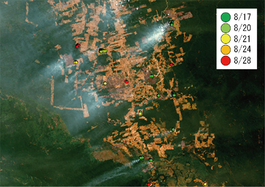
around 2 a.m. on August 23 (Japan time).
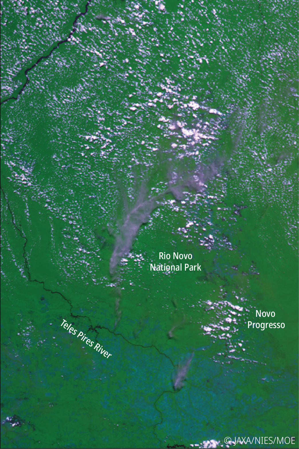
The smoke plumes from the fire is shown in gray,
that is different from cloud (sheep cloud?).
Meanwhile, the Greenhouse Gases Observing Satellite "IBUKI" captures smoke plumes caused by the fires arising in several locations as shown in Figure 2. Furthermore, the Advanced Land Observing Satellite-2 "DAICHI-2" enables to detect areas where the forest had been lost due to the fires. The Synthetic Aperture Radar called "PALSAR-2" onboarded "DAICHI-2" has outstanding permeability, and is able to obtain precise ground surface information, even if the ground is covered by clouds or smokes. In DAICHI-2 radar imagery, areas covered with more trees appear brighter and those with less trees become darker. Utilizing these characteristics, the forest loss areas between August 12 and 25 are derived by PALSAR-2 images, and such areas are marked as red dots in Figure 3.
Other than the above, there are data utilizations using multiple satellite data. "Most recently, I give an example in the case of Typhoon Faxai and Typhoon Hagibis in October 2019," TADONO Takeo of EORC says, "We estimated the amount of torrential rain, and the amount of river flow using runoff simulation model. We referred to these kinds of information as well, and prepared the emergency observation by "DAICHI-2" in order to promptly provide information about the affected areas in the case of occurring flooding." Figure 4 shows the estimated flooding area around Chikuma River basin in Nagano Prefecture, Japan caused by the Typhoon Hagibis.
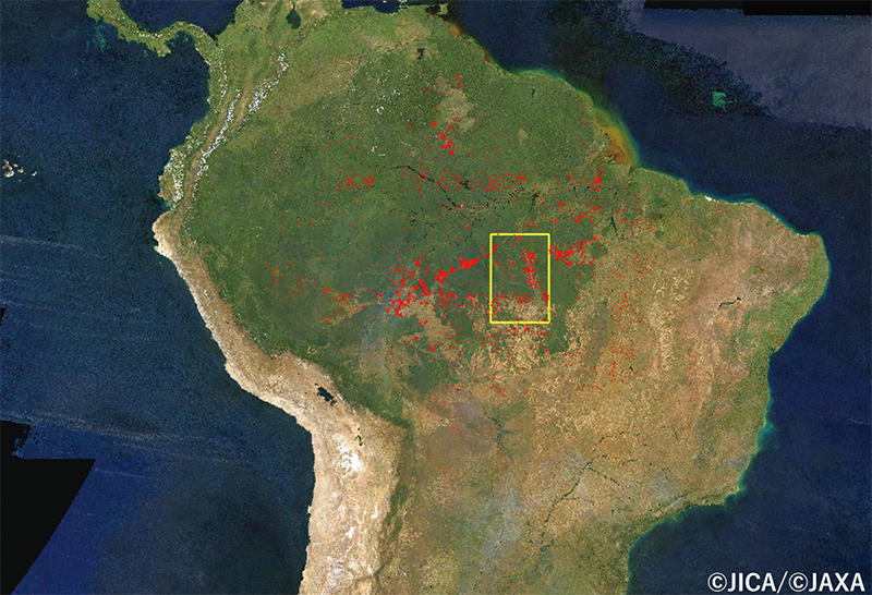
observation data between August 12 and 25 are indicated in red dots.
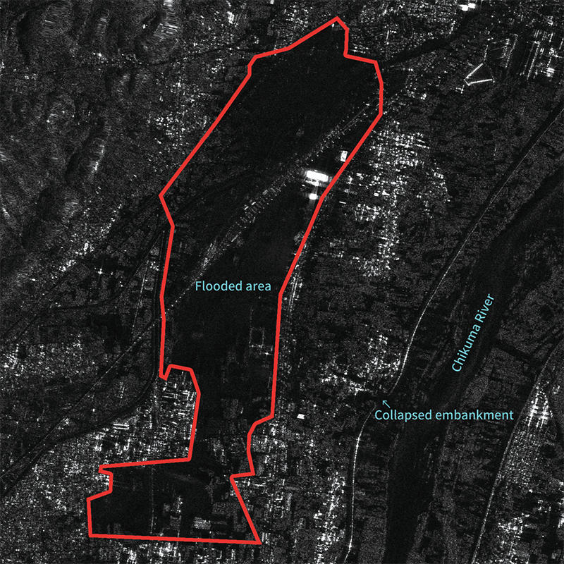
Prefecture immediately after the Typhoon Hagibis had passed,
based on the emergency observation of "DAICHI-2,"
The image shows flooded area widely caused by
collapsed embankment.
NAKAU commented, "Through combining the observation data from multiple satellites, we could discover new looks of natural disasters. The efforts provided us potential new capabilities to understand how climate change have impacts on our daily lives." Space Technology Directorate I will continue to develop technologies of satellite and Earth observations to support disaster risk reduction.
Observation images of various natural phenomena are released at
Profile

|
|
|---|

|
|
|---|
All the images are copyrighted ©JAXA unless otherwise noticed.
- Home>
- Global Activity>
- Public Relations>
- JAXA’s>
- JAXA's No.79>
- Natural Disasters monitored by Satellites The Amazon Rainforest Fires Observed by JAXA's Satellites