Space Technology Directorate I
Global Scale Monitoring of COVID-19 Impacts
Tri-Agency Collaboration Using Assembled Satellite Observation Data
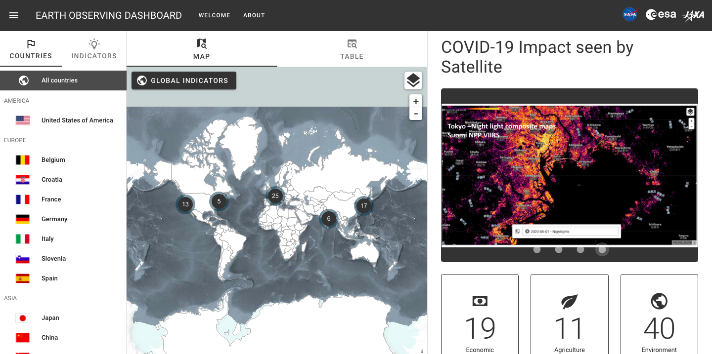
JAXA has recently engaged in launching two web platforms to visually display the impacts of the novel coronavirus (COVID-19) pandemic raging around the world. One is the COVID-19 "Earth Observing Dashboard" created jointly by JAXA, NASA and the European Space Agency (ESA) to post their assembled data analysis results.
The other is "JAXA for Earth on COVID-19," an independent platform containing the agency's proprietary analysis. The two major publication projects ("COVID-19 Project") were delivered in only two months. What has driven such a quick action? This article introduces a behind-the-scenes story shared by HIRABAYASHI Takeshi and HAMAMOTO Ko, from Space Technology Directorate I.
Three space agencies concert efforts
On June 25, 2020 (JST), two major web platforms were released to inform on ongoing impacts of the COVID-19 outbreak raging throughout the world. The two programs analyze data collected from Earth observation satellites and present changes over time in the global environment and socioeconomic activities in a visual manner, in order to strengthen global understanding of the environmental and economic effects of the pandemic.
One is COVID-19 "Earth Observing Dashboard," produced by JAXA, NASA and ESA to post the three agencies' assembled data analysis results.
The other is "JAXA for Earth on COVID-19," an independent program that contains proprietary analysis results based on the agency's observation satellite data.
The three agencies can take advantage of their Earth observation satellites equipped with various functions, including for measuring atmospheric CO2 concentrations and capturing detailed images of land surfaces, in order to design data analysis plans to meet intended purposes. To serve the recent project to grasp changes caused by the COVID-19 outbreak, the agencies analyze relevant data and present results using images and charts, with a focus on the following five areas:
- Air quality: NO2 concentrations
- Climate: CO2 concentrations
- Economic activity: Activities of ports, industrial areas, large commercial facilities
- Agriculture: Harvests and cropping on farms
- Water quality: Chlorophyll-a concentrations (Chl-a) in coastal waters
About planning of the COVID-19 Project, HIRABAYASHI Takeshi, Senior Chief Officer of Satellite Applications at Space Technology Directorate I and the project leader, said, "Our first discussion with NASA and ESA was for selecting analysis target areas. Once the five areas were decided on, five cross-agency working groups were formed to be responsible for each area."
HAMAMOTO Ko, from Satellite Applications and Operations Center, Space Technology Directorate I, and facilitator of overall project activities, including coordination with partner agencies and public relations, shared related details, saying:
"Each agency assigned one or two representatives to each working group, which held a respective online meeting every week to share analysis results and discuss web platform designs. In addition, weekly plenary meetings were held to be attended by an average 20 members from the all five groups to make overall adjustments."
HIRABAYASHI described the objective of the COVID-19 Project, as follows:
"We believe it is important to grasp what changes are occurring in the global environment and human activities in response to the spread of the virus on an ongoing basis, and satellite observations should be used for this purpose. Thus, we have decided to analyze relevant data and distribute results publicly. Also, the published data can be used for various purposes, such as environmental research and societal and economic studies. We hope the platforms will serve as an effective information source for understanding, analyzing and studying effects of the pandemic. We also believe it is important for the next generations to preserve a historical record of the changes associated with unprecedented events such as global lockdowns and self-restraint."
The platforms have been visited by many viewers from across the world, recording "88,000 accesses to 'Earth Observing Dashboard' in the first two months, according to ESA, the host of the website" (HAMAMOTO). This tool is expected to serve many more activities and purposes.
JAXA's independent platform offers exclusive content
"JAXA for Earth on COVID-19" contains the agency's original information in addition to data posted at "Earth Observing Dashboard."
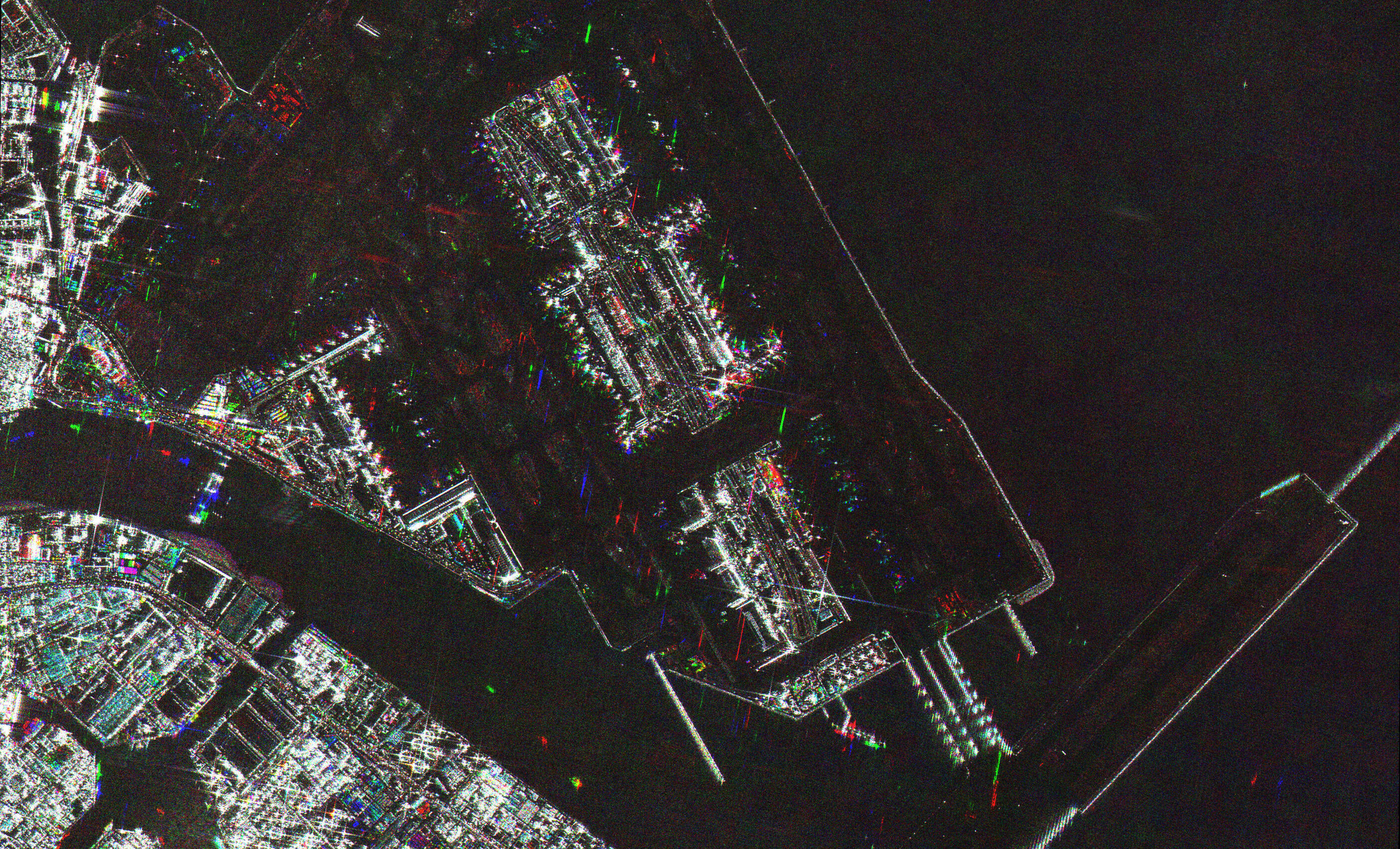
One major example is related to the situation of airports around the world. You can track changes in the number of aircraft on the loading apron and vehicles in the adjacent parking lots, from an analysis result using JAXA's original indicators applicable from before major COVID-19 outbreaks, and confirm activities in many airports being stagnated as a result of the infection.
Data used to run the program is sourced from ALOS-2 observations. "In SAR (Synthetic Aperture Radar) satellite observation images, flat areas, such as runways, appear dark while space structures, including aircraft and buildings, look light. Using this feature, JAXA's specialists read the data visually to identify individual aircraft and vehicles." (HAMAMOTO)
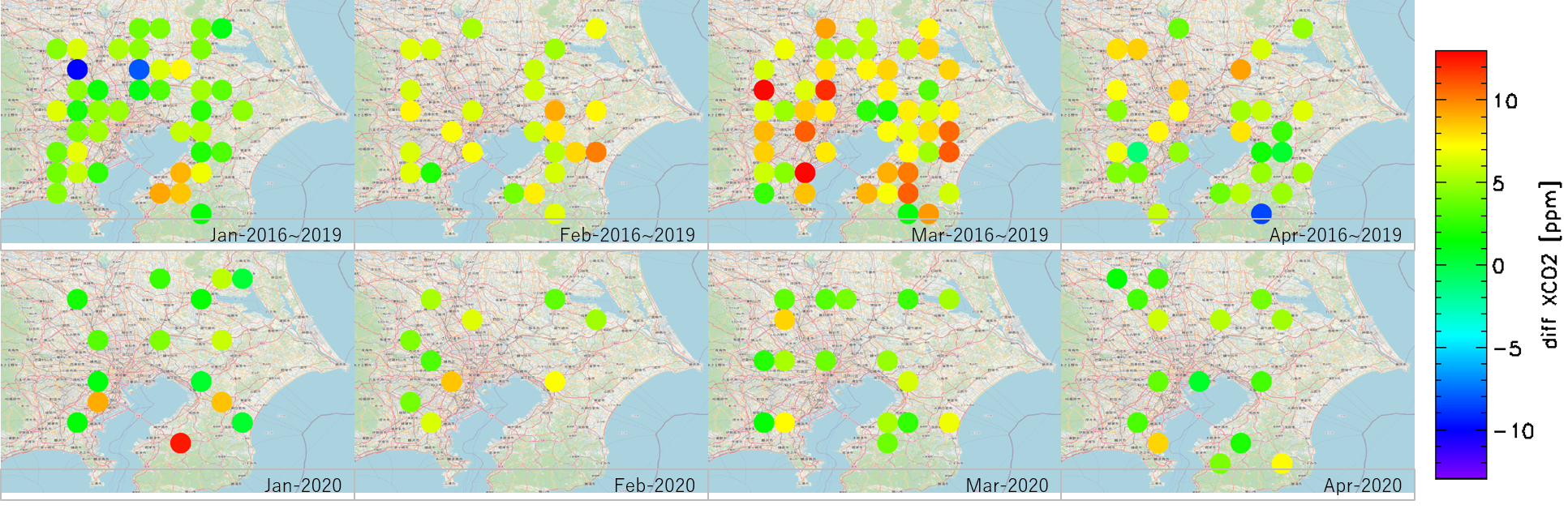
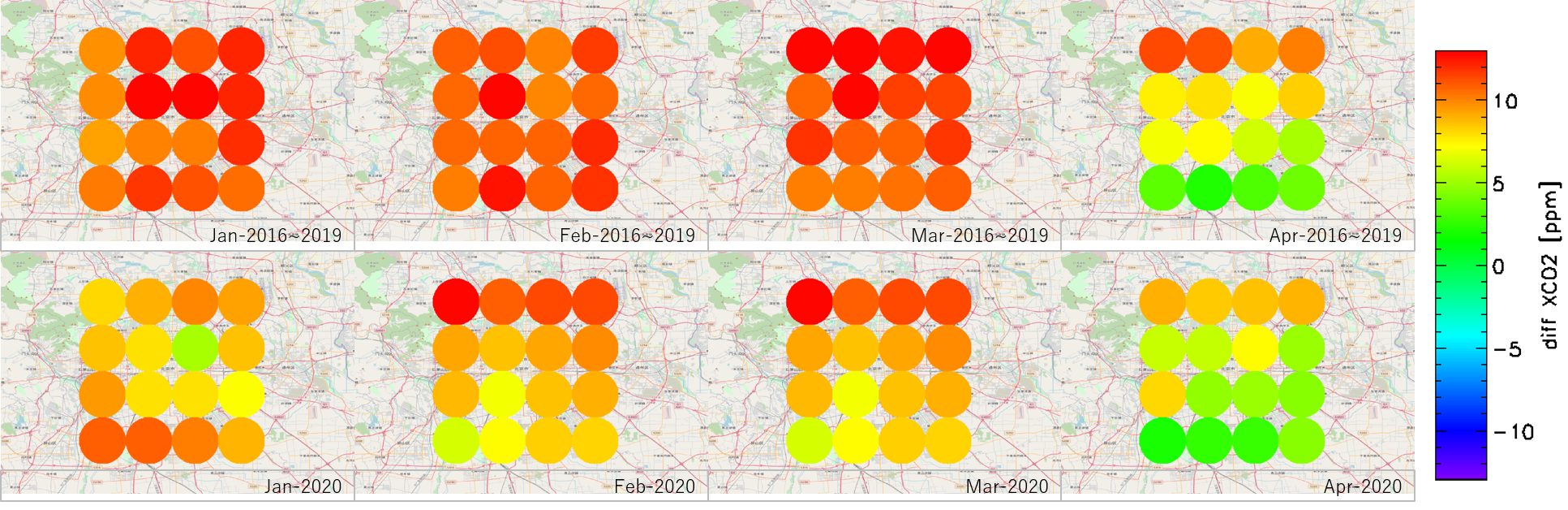
Among a set of programs offered, that for "presenting changes in atmospheric CO2 concentrations enabled by GOSAT and GOSAT-2 observations has generated particularly large public reaction," said HAMAMOTO.
"One of the world-renowned strengths of GOSAT is that its observations can be utilized to track the trend of atmospheric CO2 concentrations in large urban areas on an ongoing basis. This program has attracted a lot of media attention, receiving inquiries from TV broadcasters and newspapers."
HIRABAYASHI gave more details on the advantage of GOSAT, saying, "With respect to atmospheric CO2 observations, GOSAT outperforms other Earth observing satellites particularly for the purpose of intensive monitoring for large urban areas, and also for partial column information of upper/lower altitude. Specifically, compared with foreign satellite observing capabilities limited to the overall measurement of the entire atmospheric layer from ground to top, GOSAT is capable of altitude level-specific measurement. This function can provide CO2 concentration data only for a low-altitude layer, which allows us to gain data for areas close to CO2 generation sources. From overall atmospheric measurement, however, we can gain only average values, because CO2 is diffusing as it ascends in the air."
When posting data on "JAXA for Earth on COVID-19," "we work rigorously to confirm that phenomena detected through satellite observations coincide with changes occurring in society, in reference to media reports and other information." (HAMAMOTO)
A sense of mission as a space agency
The COVID-19 Project was implemented at an exceptionally high speed, taking merely less than two months from the project start-up to launch of the website. Looking back, HAMAMOTO said, "The biggest challenge was about starting the project."
"I worked hard to ensure that everyone at JAXA understands that we are starting from scratch, and share information to help project members develop a strong sense of purpose. During the earliest weeks, I attended an online meeting of any of the five working groups almost every evening, in order to participate in all the group meetings, serving the liaison duty.
"Another challenge was related to negotiating with world-leading engineers and scientists to achieve adequate coordination between the three agencies. I think a bilateral collaboration would have been easier to handle, and we could have had more time to prepare carefully. However, I was tasked with achieving tri-agency collaboration, and also pressed for time to advance a series of plans. I struggled very hard to keep up with the partners. At each meeting, I and other project members tried to find what we could do to make an even slightly better contribution."
The project members had to work from home in general. According to HIRABAYASHI, "at JAXA, from the beginning of April, and before the start of this collaboration project, we began to discuss the possibility of applying space technologies to address virus issues. Then, the government issued a state of emergency declaration, requiring many organizations, including JAXA, to introduce remote work at a large scale."
"Members working from home faced a number of issues, such as difficulty with accessing large-volume data. At the same time, however, we could take advantage of teleworking to make effective use of time, particularly when working together with NASA and ESA. In carrying out international collaboration activities between the three agencies, the appropriate local time of the US or Europe is to be considered, which requires members from JAXA to often work during night hours. But from home, we can use our time more effectively, for example, to take a rest ahead of a meeting and do various personal activities."
HAMAMOTO shared his comments: "While working for the tri-agency collaboration from home in Tsukuba, I often felt strangeness with a familiar neighborhood view from the window. It was associated with working with partners in the other side of the Earth at the frontier of science in an ordinary residential town setting."
"We delivered a quality project on time despite a prohibitively short lead time. I believe this was possible through the entire team sharing the firm commitment to exerting every possible effort to make even the smallest contribution despite the difficult situation. Such forward-looking mindset is one of JAXA's valuable strengths."
HIRABAYASHI, attributing the success largely to the relationships of trust between the three agencies, shared his view as follows:
"The three partners were able to work together productively on an equal footing based on long-time trusted relationships. One key to smooth progress, particularly for web platform design planning, lay in the fact that we already had a certain level of shared understanding of each other's capabilities, including about satellite data and analytical capacity.
In addition, as major space agencies, we have shared a sense of mission such as detecting global changes from space to help humankind address ongoing disaster, releasing observation data and leaving them for future generations. I believe this shared mindset drove us forward to achieving a quick and quality delivery. I will work to maintain and enhance these cooperative relationships into the future."
Profile

|
|
|---|

|
|
|---|
All the images are copyrighted ©JAXA unless otherwise noticed.
- Home>
- Global Activity>
- Public Relations>
- JAXA’s>
- JAXA's No.81>
- Global Scale Monitoring of COVID-19 Impacts Tri-Agency Collaboration Using Assembled Satellite Observation Data