Space Technology Directorate I
(from left) Before Disaster; 5 Years After Disaster; and 10 Years After Disaster
Reconstruction Progress over
10 Years from the Great East Japan Earthquake Captured by Earth Observation Satellites
JAXA's earth observation satellite system is in service around the clock to precisely monitor the situation of Earth's surface. In 2011, when the Great East Japan Earthquake occurred, the observation “eye” captured the affected areas changed drastically by the earthquake, and has continued observing the gradual progress of recovery processes over 10 years since that time. An enormous number of observation data were analyzed to present visual reporting of the recovery process. In this section, TADONO Takeo, Research Division Manager at the Earth Observation Research Center, gives an overview of the project.
Utilizing the earth observation satellites for disaster management
JAXA collects data from the earth observation satellites to utilize for monitoring of the global environment, investigation of earth resources, and many other purposes. Among them, one that is attracting growing public attention is for disaster management. 2021 marks the 10th year of the occurrence of the Great East Japan Earthquake. While inducing an unprecedented catastrophe, this natural event provided JAXA with a significant opportunity to redevelop its earth observation satellite programs.
TADONO gave related details, saying:
“JAXA started to promote disaster management initiatives using the Advanced Land Observing Satellite “DAICHI” (ALOS), which has been completed its operations. In March 2011, when the Great East Japan Earthquake occurred, ALOS was mobilized to conduct emergency observations, and after only two months, in May, the satellite operation was forced to be closed down due to a mechanical failure, which took place entirely independently of the impact of the earthquake disaster. The unanticipated failure of ALOS occurring in the immediate wake of its substantial contribution to the mission led our team to increase the awareness of the significance of the earth observation satellite program and confirm the shared recognition of disaster management as a major theme to be pursued by the program. Thus, at present, the successor satellite “ALOS-2” is tasked with providing observation data to be used for disaster management.”
In 2021, the 10th year of the massive earthquake, the Earth Observation Research Center compiled analysis results of satellite observation data to present recovery and reconstruction processes progressing in the affected areas over these years. The completed project has been published online under the title of “Disaster Reconstruction Progress over 10 Years Captured by Earth Observation Satellite.” The publication provides land cover changes (changing situation of Earth's surface) for 11 locations in the Tohoku region as an example over 10 years from the occurrence of the earthquake, a dataset resulting from analysis of observation data collected at three timings and organized into “Before Disaster,” “5 Years After Disaster” and “10 Years After Disaster.”
The land cover data have been organized for 12 categories of fields, including for urban area, rice farming, non-rice farming, grassy area, forest, and solar panel-covered area. For the purpose of analysis, the team “collected multi-temporal data of the same location to identify seasonal changes in sequence to ensure accurate classification” (TADONO). He described reasons specifically, saying:
“From collected data for multiple days in different seasons, we can find specific characteristics of each field category related to seasonal transition. For example, the seasonal cycle of rice fields is characterized by rice planting in wet fields in spring, growing crops toward summer, and harvesting in autumn. These events effect changes in lightness in the same season of the satellite images and data, which offers an effective field identifier.”
“The forest field is divided into four categories: deciduous broad-leaved forest; deciduous needle-leaved forest; evergreen broad-leaved forest; and evergreen needle-leaved forest. It is easy to distinguish between deciduous forest and evergreen forest areas. The former area looks green in color in summer and turns brownish in winter, while the latter remains green throughout the year. Distinction between broad-leaved forest and needle-leaved forest areas is more difficult due to their subtle difference and variant appearances related to species. Nonetheless, a rough but useful guide is given by the observation of needle-leaved forests becoming greenish yellow in appearance at the beginning of spring. As such, careful examination of satellite images and data for seasonal changes is vitally important.”
Progress of reconstruction efforts revealed through land cover changes
To describe findings from the data related to changes in the situation of affected areas in the Tohoku region, TADONO introduces cases of three locations out of the 11 subjects to survey.
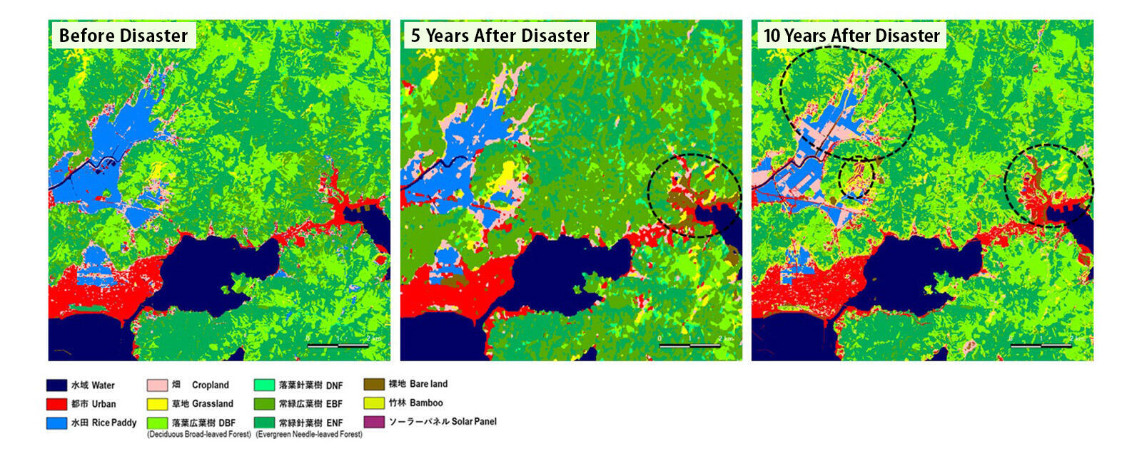
The first case location is found in Minamisoma City, Fukushima Pref., and contains areas north of the Fukushima Daiichi Nuclear Power Station.
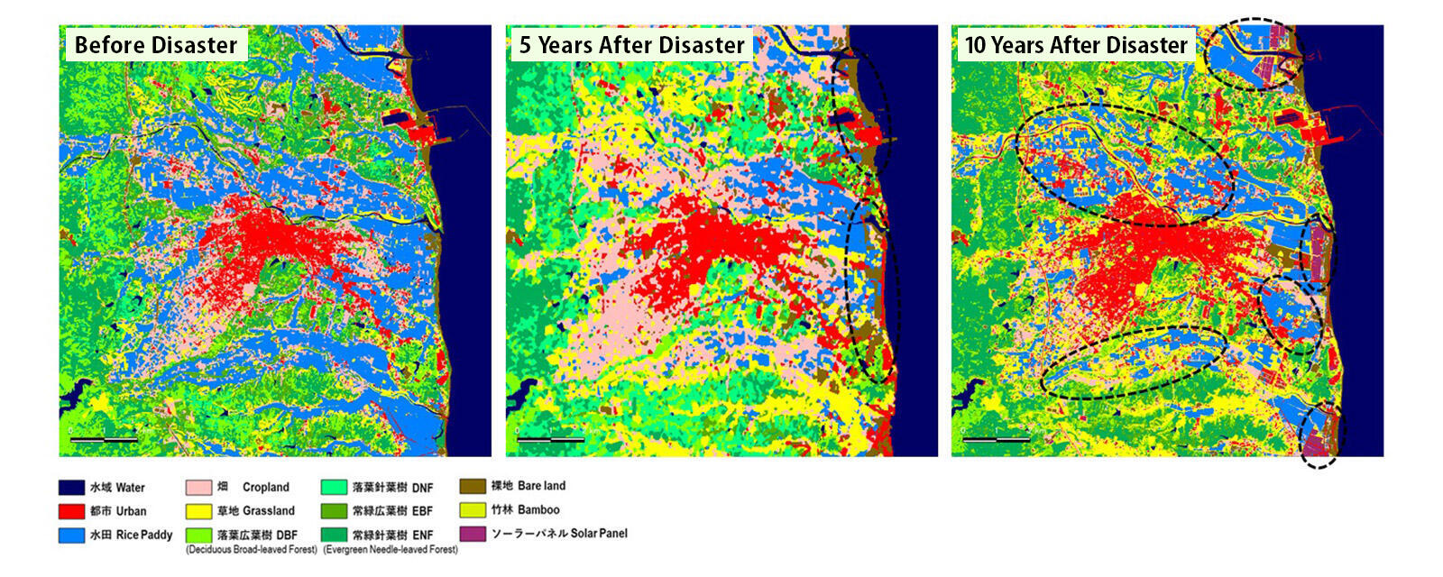
“The Before Disaster data shows large rice field plain areas (indicated in light blue in images). In 5 Years After Disaster, grassy areas (yellow) have appeared in the southern region that was previously used for rice farming. This region contains a sizable area of abandoned cultivated land and prohibited districts as a result of the earthquake disaster and the associated nuclear accident, a probable factor for the shift from rice field to grassy area.”
“From 10 Years After Disaster, you can notice an increased area of rice field in the relevant region. You will see similar changes appearing in districts north of the urban area (red). This seems to indicate the resumption of rice farming operations in the districts.”
“More distinctive characteristics are revealed by data related to the solar panel covered land area (purple), which provides the fact that a large number of photovoltaic power stations and large solar power plants were constructed during the post-disaster decade, a phenomenon witnessed commonly in the entire Tohoku region.”
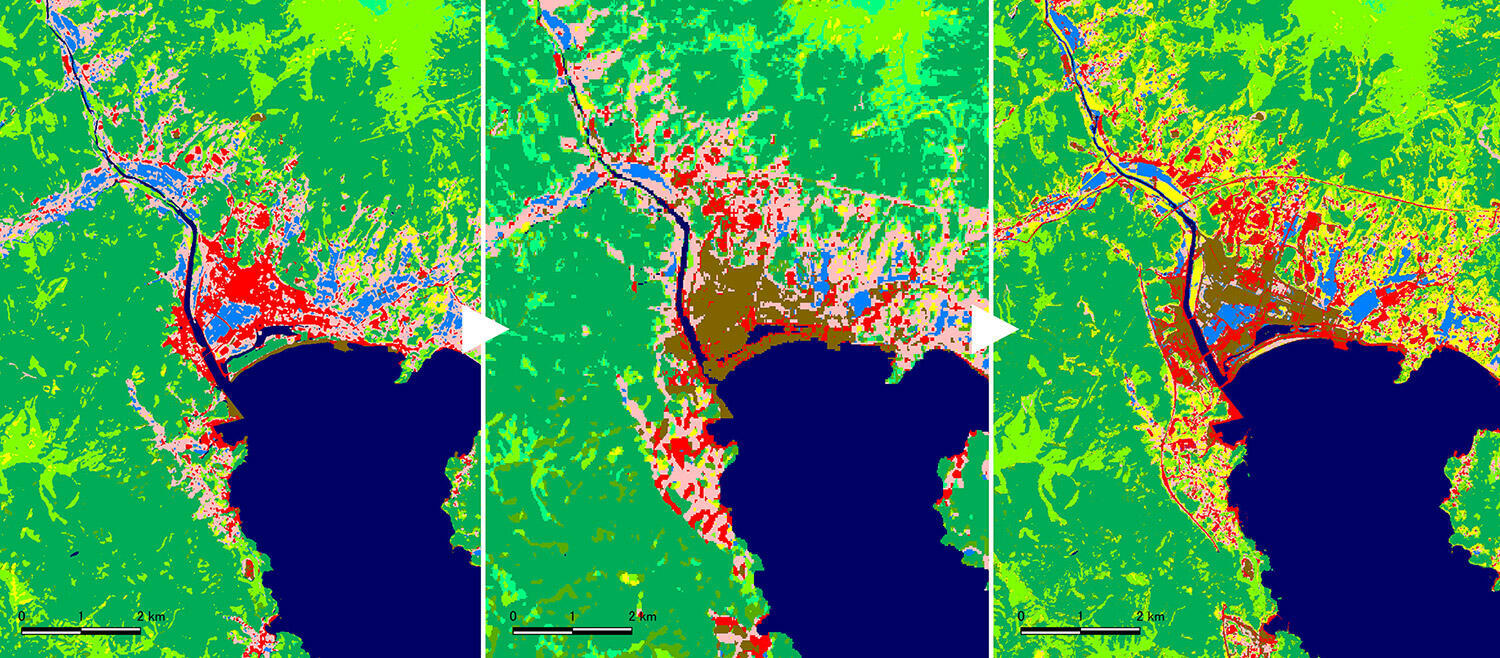
“The second case is from Rikuzentakata City, Iwate Pref., which has a small port town located on the Sanriku ria coast. Before Disaster shows the urban area lying along the bay, which is surrounded by rice fields. In 5 Years After Disaster, this area as a whole has tuned into a bare land area (brown). This is considered to primarily represent severe damage from the tsunami disaster, but in our view, this data also indicates an outcome of ground-clearing work implemented to prepare the damaged land for building new communities.”
“In 10 Years After Disaster, you can see the district north of the former urban area dotted with new urban areas. We think this reflects the relocation of residential and commercial functions to highland regions. Look at the coastal region, where urban areas have slightly expanded. This is considered to signify reconstructed embankments and reinforced shore protections, as the category of “urban area” includes manmade structures.”
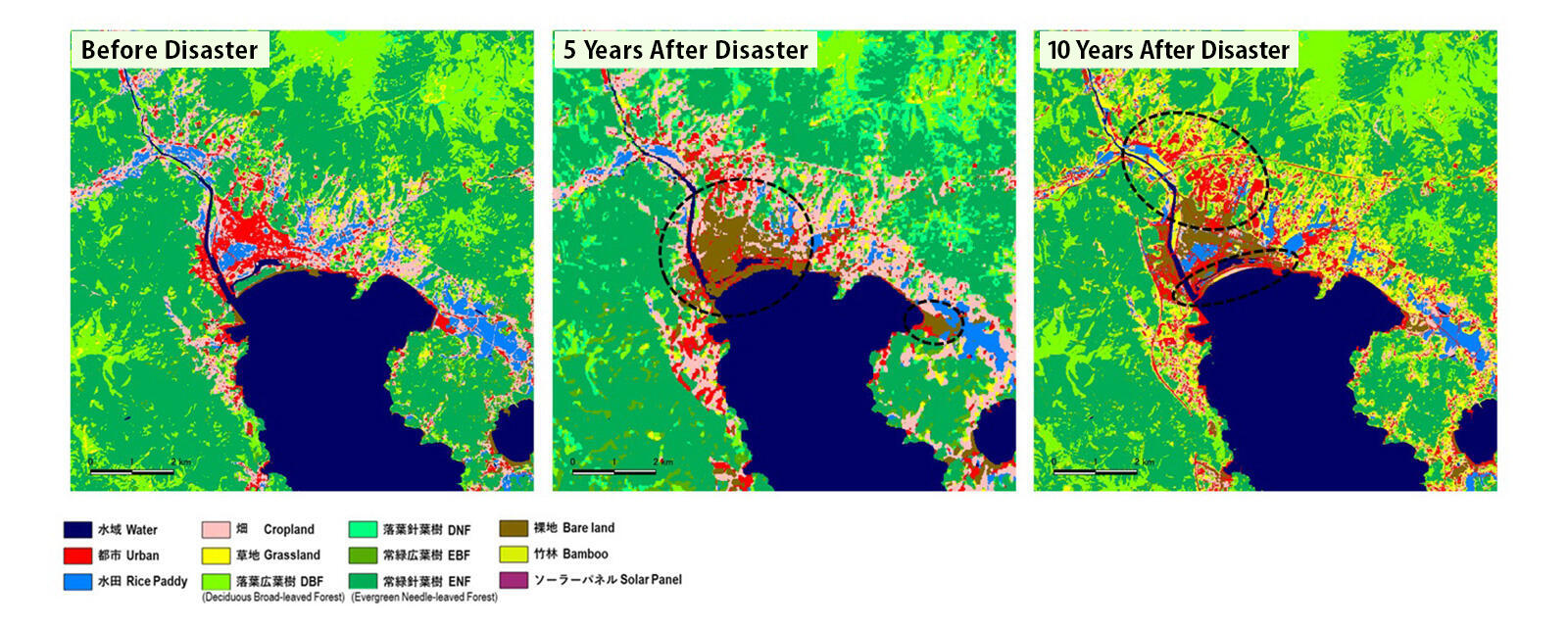
“The last case is related to Ishinomaki City and Onagawa Town, Iwate Pref. Before Disaster shows urban areas extending around the coastal region and rice fields in inland regions. In 5 Years After Disaster, bare land areas appear in the Onagawa area on the right side (of the map), which were previously covered by rice fields. We think that this signifies a consequence of the tsunami disaster.”
“Look at 10 Year After Disaster, you can find urban areas appearing in inland regions, deeper than where the former urban areas of Onagawa were situated. Look at the two circles in top left corner, which represent urban areas growing in districts north of the previous rice field area, an apparent indication of new construction of residential districts implemented in highland regions, a similar situation observed in the Rikuzentakata case.”
Aiming at the new goal of helping disaster prediction
Looking back on the recent compilation project, TADONO expresses his condolences to many affected people who are still struggling with ongoing challenges to rebuild their lives. He also voices a sense of relief he had when recognizing reconstruction processes steadily progressing, as indicated by the compiled observation data. Then, he continued to refer to new research and development initiatives launched to utilize observation data to make more contribution to disaster management.
“Our past efforts have been predominantly directed at emergency observations during a disaster and following monitoring of post-disaster reconstruction situations. In the future, we will shift our focus more on disaster prediction. More specifically, we are developing capabilities to detect effective predictors. One such example is subtle movements of land to be observed before large-scale landslide and mudslide events start to cause a massive ground collapse. In addition, we are considering programs to offer to improve hazard maps prepared by individual local governments for disaster preparedness. Our plan is to keep the map updated using the latest available satellite observation data in order to increase the accuracy and effectiveness of the map, thereby hoping to help create a safe and secure society.”
“Previously, when ALOS was in service, we had yet to establish adequate technologies to utilize observation data for the purpose of disaster management. At present, we have developed appropriate capabilities to process observation data in a way as to be offered to regional disaster-related institutions for individual local purposes. Please allow us to be proud of this major achievement from efforts of the past decade. Going forward, we will step up our research and development activities aimed at disaster prediction, hoping to contribute to better quality of life of many more people” (TADONO).
Profile

|
|
|---|
All the images are copyrighted ©JAXA unless otherwise noticed.
- Home>
- Global Activity>
- Public Relations>
- JAXA’s>
- JAXA's No.84>
- Reconstruction Progress over 10 Years from the Great East Japan Earthquake Captured by Earth Observation Satellites