Monitoring infrastructure from space
— Tell us about your responsibilities and projects.
 Advanced Land Observing Satellite DAICHI (courtesy: JAXA)
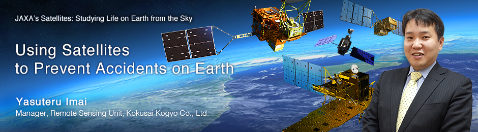
Kokusai Kogyo Co.,Ltd. was founded in 1947 as a technology-services company focused on spatial information technology. The Remote Sensing Unit, which I manage, provides services using data acquired from satellites and aircraft. We became involved in the satellite business in the 1980s, and were an early adopter of satellite imaging systems. Initially we were relying on foreign satellites, but now we also use a significant amount of data from JAXA satellites. We have an extensive track record going back to the Japanese Earth Resources Satellite JERS-1, launched in 1992, and the Advanced Earth Observing Satellite ADEOS, launched in 1996. Notably, with the launch of the Advanced Land Observing Satellite (ALOS) DAICHI in 2006, our activities expanded from research and creating maps of developing countries to many other areas, including forestry, agriculture, environment, disaster management, and resource management. We use many different types of data, including that obtained from optical sensors that observe both visible and infrared wavelength, as well as SAR data obtained from radio waves.
— SAR refers to the phased array type L-band Synthetic Aperture Radar (PALSAR), deployed on the DAICHI satellite. How exactly is SAR data used?
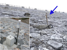
 Rockfill dam in Okinawa
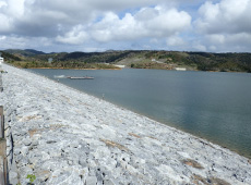
Dam body displacement. Darker red pixels indicate increased amounts of subsidence.
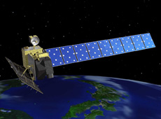
The key benefit of SAR is the ability to make observations regardless of time of day or weather. We are developing methods of observing infrastructure and ground subsidence using SAR data. We can track changes at a given location based on multiple observations over time with SAR. This technology is known as “Differential Interferometric SAR (DInSAR),” and we have a joint research project with Public Works Research Institute (PWRI) and Yamaguchi University to use this technology to measure the displacement of dam bodies. Dam bodies can experience displacement due to water pressure at the dam wall, causing slight sinking and deformation. We track these changes.
We also provide a service to monitor displacement 24 hours a day by installing small GPS sensors we’ve developed in house onto slopes that have a risk of mudslides or could cause damage to dams. But these GPS sensors provide only part of the picture: they can give us an accurate reading of the deformation at each specific location, but they cannot provide information on the entire area of the dam. So we have started a project to observe total displacement of dam bodies by combining GPS and SAR data. We have discovered some variances when conducting experiments and comparing GPS and SAR data, but the displacement patterns are very similar, which we feel proves the reliability of SAR-based displacement analysis.
We performed experiments on a rock-fill dam in Okinawa, which is different from a concrete dam in that it is made from rocks and soil. There are almost 2,000 dams like this in Japan. They are not as stable as concrete, and therefore the reservoirs are prone to sinking. Because of this, Japan has regulations requiring this displacement to be measured regularly. The measurements are generally done with electro-optical distance measurement, but there has been movement recently towards using GPS. This method is less expensive in the long term than the labor-intensive electro-optical distance measurement, and also more efficient and more accurate.
GPS sensors are becoming smaller and cheaper, but this is, of course, relative. One GPS unit that can measure displacement of dam bodies costs several hundred thousand yen, and of course you need multiple points of measurement for each dam body. To lower costs, we intend to create more of a balance by getting rough measurements from satellites and then using GPS for further investigation if anomalies are detected. Satellites can observe large areas at once, which makes it possible to measure several dozen dams at the same time. For this reason, using satellites instead of relying solely on GPS should be cost- effective and ultimately lead to reduced costs.
What’s important is results, and quality of information
— In the future, do you plan to rely solely on satellite measurements?
 Monitoring infrastructure using GPS
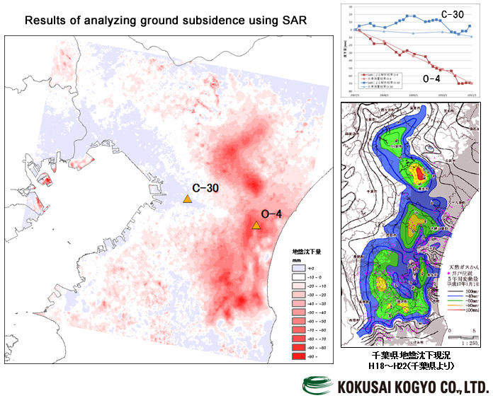
Ground subsidence. Darker red pixels indicate increased amounts of subsidence. (courtesy: Kokusai Kogyo Co., Ltd.)
No, not at all. I don’t believe that satellites can completely replace existing methods. Looking at GPS vs. satellite data, for example, using satellites is more cost effective, but GPS has better accuracy, so you can’t readily say which is better. I think we need to take advantage of the benefits offered by satellites used in combination with existing methods. Current ideas include eliminating unnecessary costs and obtaining accurate information more efficiently. We are evaluating the practicality of using SAR and the accuracy of such data.
— What are the challenges of increased use of satellite data?
Satellite technology has improved enormously, and there is much more usable data available, but today there is still little awareness of the possible applications of remote sensing. There is little familiarity with SAR data in particular, as it is different from images taken by optical sensors, which are easy to understand visually. Analysis using DInSAR technologies is a complex field even among remote sensing technologies. The major challenges going forward include educating customers on the benefits of using satellites, including cost effectiveness; increasing usage; and raising awareness by working closely with academia.
We also hope that satellite data will be used in regular infrastructure monitoring. Using satellites to help reduce harm from natural disasters is vital, and could really increase the general public’s interest in satellites, but unfortunately the effect would likely be short-lived. We believe that as day-to-day applications for satellites continue to accumulate, their acceptance by the public will grow more and more.
— Why is it important for users to understand the value of satellite images?
Monitoring requires speed, accuracy and continuity. Customers don’t care which specific methods are used, such as GPS or SAR. They want the perfect balance of speed, accuracy and continuity in acquiring data. What’s important is results, and the quality of the information provided. The ability to collect data consistently for 10, 20 or 30 years is a requirement. We already provide GPS-based infrastructure monitoring, which requires both frequent observation and continuity at the site. These same qualities will be expected of SAR-based monitoring as well. DInSAR requires the same location to be observed at least twice, so that changes can be analyzed, so I think it’s important to increase the frequency of observations even more. It took 15 years before GPS-based monitoring services became practical. We hope to make SAR a practical and viable solution by slowly and steadily accumulating successful results.
Increasing usage with the DAICHI-2 satellite
— JAXA has started to release images from the new Advanced Land Observing Satellite-2, also known as DAICHI-2. What are your thoughts on this?
 Advanced Land Observing Satellite-2 DAICHI-2 (courtesy: JAXA)
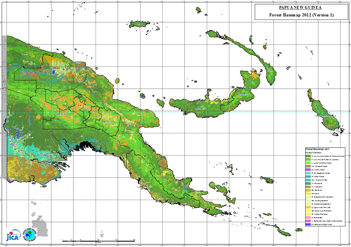
Forests in Papa New Guinea. This image indicates where forests are located, and what types of forests they contain. (courtesy: JICA)
Of course we plan to use data from DAICHI-2. The resolution of SAR images from DAICHI was 10 meters, and now, with DAICHI-2, it’s improved to 3 meters. That means we can monitor even smaller structures. We plan to use SAR data to monitor structures other than dams, such as viaducts, roads, river dykes, and slopes with a risk of collapse. We also plan to apply the knowledge we gain from our work on dams to other areas.
— Could you elaborate on specific applications?
Monitoring infrastructure using SAR has just begun, actually, but we are also finding satellite data to be useful in forestry, agriculture, and disaster management. For example, optical sensors and SAR data are used to monitor forests: acquiring information on deforestation, degradation, and species has been valuable in forest conservation. Specific examples include the REDD+ activities, which conserve forests in developing countries in order to slow down global warming. They have analyzed all the forests in certain countries, such as Lao P.D.R and Papua New Guinea. Agricultural examples include rice-crop surveys. These activities also rely on data from both optical sensors and SAR.
In the field of disaster management, we can track ground movement such as subsidence and crustal movements. In Japan, which is prone to earthquakes, techniques have been developed over many years to better predict earthquakes by tracking crustal movements. This type of monitoring has been primarily performed with ground-based sensors, but we want to incorporate satellite data into the process. As you can see, satellite data has many uses. We expect observations from the new DAICHI-2 satellite to be applicable in many areas and scenarios as well. Previously, satellite data was mostly used for public-works projects; going forward, we want to provide services to private customers as well.
The advantage of having our own satellites
— What can be expected from JAXA?
We have been involved in many overseas projects – through the Japan International Cooperation Agency (JICA) and so on – but now many customers are coming to Japan to use our satellites, which is a significant advantage. There is strategic value in using exclusively Japanese technology for everything from observation to consulting. So we want to see more and more satellites launched, for practical use as well as for technology development. Having more satellites would also allow more frequent observations. JAXA has often used just one satellite to perform many different kinds of observations for various research projects. DAICHI had nearly 100 PALSAR observation modes to comply with differing observation angles and polarizations, which severely limited the time allocated to any one observation. We would really like to see a satellite that is optimized for DInSAR, even if it’s a small satellite. We have a large infrastructure base, and there is strong demand for infrastructure monitoring. Therefore, we would like to be able to monitor Japan's infrastructure with SAR 24 hours a day, 365 days a year.
- Photos courtesy:
- Public Works Research Institute (PWRI), Kokusai Kogyo Co., Ltd., except as indicated
Yasuteru Imai
Manager, Remote Sensing Unit, Kokusai Kogyo Co., Ltd.
Mr. Imai graduated from Tohoku University with a major in environmental science in 1998, and was hired by Kokusai Kogyo Co., Ltd. the same year. He has worked as a researcher at the Waseda University Environment Research Institute, and as an adjunct professor at the Center for Environmental Remote Sensing of Chiba University. He is a member of the Japan Society of Photogrammetry and Remote Sensing, and of the Remote Sensing Society of Japan.
[ Mar. 13, 2015 ]
- Using Satellites to Prevent Accidents on Earth
- Satellites Watch Over the Northern Sea Route
- A Digital 3D Map to Support Life Around the World
- A Learning Program by Using Satellite Data
- Using Satellites to Make Art on Earth